Ōita Prefecture
Lua error in Module:Unicode_data at line 293: attempt to index local 'data_module' (a boolean value). is a prefecture in the Kyūshū region of Japan on the island of Kyūshū.[1] The capital city is Ōita.[2] Ōita is well known in Japan for its many hot springs.
| Ōita Prefecture | |||||||||
| |||||||||

| |||||||||
| Capital | Ōita | ||||||||
| Region | Kyūshū | ||||||||
| Island | Kyūshū | ||||||||
| Governor | Katsusada Hirose | ||||||||
| Area (rank) | 6,338.82 km² (24th) | ||||||||
| - % water | 0.7% | ||||||||
| Population (Oct 1, 2005) | |||||||||
| - Population | 1,209,587 (34th) | ||||||||
| - Density | 191 /km² | ||||||||
| Districts | 3 | ||||||||
| Municipalities | 18 | ||||||||
| ISO 3166-2 | JP-44 | ||||||||
| Website | www.pref.oita.jp/english/ | ||||||||
| Prefectural Symbols | |||||||||
| - Flower | Bungo-ume blossom (Prunus mume var. bungo) | ||||||||
| - Tree | Bungo-ume tree (Prunus mume var. bungo) | ||||||||
| - Bird | Japanese white-eye (Zosterops japonica) | ||||||||
| - Fish | |||||||||
 Symbol of Ōita Prefecture | |||||||||
| Template ■ Discussion | |||||||||

History
In the 6th century, one of the regions of Kyushu was divided into Bungo Province and Buzen Province.
After the Meiji Restoration, districts from Bungo and Buzen provinces were combined to form Ōita Prefecture.[3]
Timeline
- 1184 (Juei 3): Usa Shrine was destroyed by fire in Gempei War.[4]
- November 19, 1274 (Bun'ei 11, 20th day of the 10th month): Battle of Bun'ei[5]
- August 15, 1281 (Kōan 4, 30th day of the 7th month): Battle of Kōan[6]
- 2002 (Heisei 15): FIFA World Cup in Ōita[4]
Geography
Ōita Prefecture is on the north-eastern section of the island of Kyūshū.
Ōita is faces the Suo Channel and Honshū Island to the north. The prefecture looks towards the Iyo Channel and Shikoku Island to the east. It is bordered by Miyazaki Prefecture to the south. Fukuoka Prefecture and Kumamoto Prefecture are to the west.
Cities
Towns and villages
National Parks
National Parks are established in about 28% of the total land area of the prefecture.[7]
Shrines and Temples
Sasamuta-jinja, Usa-jinjū and Yusuhara Hachiman-gū are the chief Shinto shrines (ichinomiya) in the prefecture.[8]
Fukiji Temple has the oldest wooden structure in Kyushu.
The Usuki Buddhas include 60+ cliff carvings from Heian period.
Ōita Prefecture Media
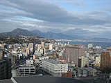
Ōita seen from Takasago. Ōita harbor in front right, behind that the Beppu Bay. Motorway 10 in front left, behind Takasaki Yama.

日本国大分県日田市の亀山公園を、同市南部にある鏡坂公園から撮影。

- ViewofBeppu
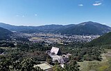
Panorama view of Yufuin from Sagiridai Viewpoint. Taken on 18 October 2011.

Lookout from Saiki castle ruins

Oita prefecture population pyramid in 2020


Related pages
References
- ↑ Nussbaum, Louis-Frédéric. (2002). "Ōita-ken" in Japan Encyclopedia, p. 742; Japan External Trade Organization (JETRO), Oita Prefecture, Regional Information[dead link]; retrieved 2012-4-6.
- ↑ Nussbaum, "Ōita" at p. 742.
- ↑ Nussbaum, "Provinces and prefectures" at p. 780.
- ↑ 4.0 4.1 Oita Municipal Guide Book, History of Ōita Archived 2012-03-09 at the Wayback Machine; retrieved 2012-2-9.
- ↑ Davis, Paul K. (2001). 100 decisive battles: from ancient times to the present, pp. 145-147; History of Ōita Archived 2012-03-09 at the Wayback Machine; the noun "Bun'ei" means the Japanese era name (nengō) for a time period started in February 1264 and ended in April 1275
- ↑ Davis, p. 147; History of Ōita Archived 2012-03-09 at the Wayback Machine; the noun "Kōan" means the Japanese era name for a time period which started in February 1278 and ended in April 1288.
- ↑ Japan Ministry of the Environment, "General overview of area figures for Natural Parks by prefecture"; retrieved 2012-3-13.
- ↑ "Nationwide List of Ichinomiya," p. 3 Archived 2013-05-17 at the Wayback Machine; retrieved 2012-2-9.
Other websites
![]() Media related to Ōita prefecture at Wikimedia Commons
Media related to Ōita prefecture at Wikimedia Commons
- http://www.pref.oita.jp/english/index.html Archived 2006-12-05 at the Wayback Machine, (in Japanese)
- O-net Magazine Archived 2011-10-28 at the Wayback Machine
- Oita International Wheelchair Marathon Site Archived 2018-12-20 at the Wayback Machine
Coordinates: 33°14′17.47″N 131°36′45.38″E / 33.2381861°N 131.6126056°E