Armançon
The Armançon is a river in France. It is a right tributary of the Yonne river. It flows mostly through the Bourgogne-Franche-Comté region.
| Armançon | |
|---|---|
| Progression | Template:RYonne |
| Length | 202 km (126 mi) |
Eight communes have the name of the river in their names: Aisy-sur-Armançon, Argenteuil-sur-Armançon, Brienon-sur-Armançon, Chailly-sur-Armançon, Montigny-sur-Armançon, Pacy-sur-Armançon, Perrigny-sur-Armançon, Saint-Martin-sur-Armançon.
Geography
The Armançon river has a length of 202.1 km (125.6 mi) and a drainage basin with an area of 3,077 km2 (1,188 sq mi).[1]
Its average yearly discharge (volume of water which passes through a section of the river per unit of time) is 28.90 cubic metres per second at Brienon-sur-Armançon in the Yonne department.[2]
Course
The source of the Armançon is in the natural region of Auxois, about 2 kilometres (1.2 mi) to the northwest of the town Meilly-sur-Rouvres, Côte-d'Or department, at an altitude of about 420 m (1,378 ft).[3]
The Armançon flows, in general, to the northwest and passes through the following regions, departments and communes:[1]
- Bourgogne-Franche-Comté region
- Côte-d'Or: Meilly-sur-Rouvres, Chailly-sur-Armançon, Bellenot-sous-Pouilly, Éguilly, Gissey-le-Vieil, Beurizot, Saint-Thibault, Normier, Clamerey, Marcigny-sous-Thil, Brianny, Montigny-sur-Armançon, Flée, Pont-et-Massène, Semur-en-Auxois, Millery, Genay, Villaines-les-Prévôtes, Viserny, Athie, Senailly, Saint-Germain-lès-Senailly, Quincy-le-Vicomte, Quincerot, Saint-Rémy, Buffon, Rougemont,
- Yonne: Aisy-sur-Armançon, Perrigny-sur-Armançon, Cry, Nuits, Ravières, Fulvy, Chassignelles, Ancy-le-Franc, Argenteuil-sur-Armançon, Pacy-sur-Armançon, Vireaux, Lézinnes, Ancy-le-Libre, Argentenay, Tanlay, Saint-Martin-sur-Armançon, Tonnerre, Junay, Vézinnes, Dannemoine, Cheney, Tronchoy, Roffey, Bernouil, Flogny-la-Chapelle, Villiers-Vineux, Percey, Jaulges, Butteaux, Germigny, Chéu, Saint-Florentin, Vergigny, Mont-Saint-Sulpice, Brienon-sur-Armançon, Ormoy, Esnon, Cheny, Migennes, Charmoy
- Grand Est region
Finally, it flows, as a right tributary into the Yonne river at the limits of the communes Migennes and Cheny, in the Yonne department, at 81 m (266 ft) of altitude.[4]
Main tributaries
The main tributaries, with a length greater than 30 km, of the Armançon are (only right tributaries because the left tributaries are very short):
Gallery

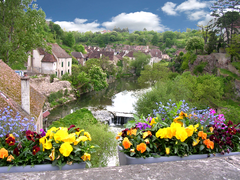
The Armançon river at Cry.
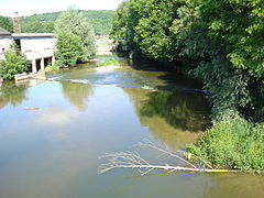
The Armançon from the Joly bridge, Semur-en-Auxois

The Pinard bridge over the Armançon, Semur-en-Auxois.
The Armançon at Tonnerre


_15-08-2006.JPG)
.JPG)
Related pages
References
- ↑ 1.0 1.1 "L'Armancon (F3--0210)" (in français). SANDRE - Portail national d'accès aux référentiels sur l'eau. Retrieved 2 October 2014.
- ↑ "L'ARMANCON à BRIENON-SUR-ARMANCON" (in français). Banque Hydro. Archived from the original on 3 March 2016. Retrieved 2 October 2014.
- ↑ "Source de l'Armançon" (in français). Géoportail. Retrieved 2 October 2014.
- ↑ "Confluence de l'Armançon" (in français). Géoportail. Retrieved 2 October 2014.
- ↑ "Fiche cours d'eau (F33-0400)" (in français). SANDRE - Portail national d'accès aux référentiels sur l'eau. Retrieved 2 October 2014.
- ↑ "Fiche cours d'eau (F34-0400)" (in français). SANDRE - Portail national d'accès aux référentiels sur l'eau. Retrieved 2 October 2014.
Other websites
- Banque Hydro - Station H2482010 - L'Armançon à Brienon-sur-Armançon (Synthèse) Archived 2015-02-19 at the Wayback Machine (in French)