Bryansk Oblast
Bryansk Oblast (Russian: Бря́нская о́бласть, Bryanskaya oblast), also known as Bryanshchina (Russian: Брянщина, pronounced [ˈbrʲænʲɕːɪnə]) is a federal subject of Russia. Specifically, it is an oblast. Its administrative center (capital city) is the city of Bryansk. As of the 2021 Census, its population was 1,169,161.[12]
| Bryansk Oblast Брянская область (Russian) | |||
|---|---|---|---|
| — Oblast — | |||
| |||
| |||
| Political status | |||
| Country | Russia | ||
| Federal district | Central[2] | ||
| Economic region | Central[3] | ||
| Established | July 5, 1944[4] | ||
| Administrative center | Bryansk | ||
| Government (as of November 2014) | |||
| • Governor[6] | Alexander Bogomaz[5] | ||
| • Legislature | Oblast Duma[6] | ||
| Statistics | |||
| Area (as of the 2002 Census)[7] | |||
| • Total | 34,900 km2 (13,500 sq mi) | ||
| Area rank | 62nd | ||
| Population (2010 Census)[8] | |||
| • Total | 1,278,217 | ||
| • Rank | 38th | ||
| • Density[9] | 36.63/km2 (94.9/sq mi) | ||
| • Urban | 69.1% | ||
| • Rural | 30.9% | ||
| Population (January 2021 est.) | |||
| • Total | 1,182,682[10] | ||
| Time zone(s) | MSK (UTC+04:00) | ||
| ISO 3166-2 | RU-BRY | ||
| License plates | 32 | ||
| Official languages | Russian[11] | ||
| Official website | |||


Geography
Bryansk Oblast is in western European Russia. It borders Smolensk Oblast in the north, Kaluga Oblast in the northeast, Oryol Oblast in the east, Kursk Oblast in the southeast, the Ukrainian oblasts of Chernihiv and Sumy in the south, and the Belarusian oblasts of Gomel and Mogilev in the west. Belgorod Oblast has a temperate continental climate.
Contamination
Because of the Chernobyl disaster on April 26, 1986, part of the area of Bryansk Oblast has been contaminated with radionuclides (mainly Gordeyevsky, Klimovsky, Klintsovsky, Krasnogorsky, Surazhsky, and Novozybkovsky Districts). In 1999, around 226,000 people lived in areas with the contamination level above 5 Curie/km2. This was about 16% of the oblast's population.
Administrative divisions
Economy
Transportation
A large railway junction is in the oblast's capital of Bryansk. There are several major customs terminals in the oblast.
The oblast is crossed by the M3 Moscow—Kiev highway and the M13 Bryansk-Novozybkov-Boundary Belarus—(Kobrin), and fourteen kilometers from the administrative center of the oblast is the Bryansk International Airport.
Demographics
Population: 1,278,217 (2010 Census);[8] 1,378,941 (2002 Census);[13] 1,474,785 (1989 Census).[14]
- Births (2012): 14 376 (11.4 per 1000)
- Deaths (2012): 20 356 (16.1 per 1000)
Largest cities and towns
Largest cities or towns in Bryansk Oblast
2010 Russian Census | |||||||||
|---|---|---|---|---|---|---|---|---|---|
| Rank | Administrative Division | Pop. | |||||||
.jpg) Bryansk  Klintsy |
1 | Bryansk | City of oblast significance of Bryansk | 415,721 |  Novozybkov  Dyatkovo | ||||
| 2 | Klintsy | Town of oblast significance of Klintsy | 62,510 | ||||||
| 3 | Novozybkov | Town of oblast significance of Novozybkov | 40,553 | ||||||
| 4 | Dyatkovo | Dyatkovsky District | 29,439 | ||||||
| 5 | Unecha | Unechsky District | 26,197 | ||||||
| 6 | Karachev | Karachevsky District | 19,715 | ||||||
| 7 | Starodub | Town of oblast significance of Starodub | 19,010 | ||||||
| 8 | Zhukovka | Zhukovsky District | 18,269 | ||||||
| 9 | Seltso | Town of oblast significance of Seltso | 17,934 | ||||||
| 10 | Pochep | Pochepsky District | 17,161 | ||||||
Ethnic groups
- Russians - 96.7%
- Ukrainians - 1.1%
- Belarusians - 0.4%
- Armenians - 0.4%
- Romani people - 0.3%
- Jews - 0.1%
- Others - 1%
- 26,825 people were registered from administrative databases, and could not declare an ethnicity. It is estimated that the proportion of ethnicities in this group is the same as that of the declared group.[15]
Bryansk Oblast Media
Anthem of Bryansk Oblast

Sevsk in 1917

Bryansk Oblast products treemap, 2020

View from the rails in Bryansk Oblast

Oblast Duma seat in Bryansk

Life expectancy at birth in Bryansk Oblast

The Spaso-Grobovskaya built in 1904
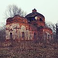
Ruins of the church in the village Veliky Bor of Gordeevsky district of Bryansk region built in 1809

.svg)
.jpg)


References
- ↑ Law #47-Z
- ↑ Президент Российской Федерации. Указ №849 от 13 мая 2000 г. «О полномочном представителе Президента Российской Федерации в федеральном округе». Вступил в силу 13 мая 2000 г. Опубликован: "Собрание законодательства РФ", №20, ст. 2112, 15 мая 2000 г. (President of the Russian Federation. Decree #849 of May 13, 2000 On the Plenipotentiary Representative of the President of the Russian Federation in a Federal District. Effective as of May 13, 2000.).
- ↑ Госстандарт Российской Федерации. №ОК 024-95 27 декабря 1995 г. «Общероссийский классификатор экономических регионов. 2. Экономические районы», в ред. Изменения №5/2001 ОКЭР. (Gosstandart of the Russian Federation. #OK 024-95 December 27, 1995 Russian Classification of Economic Regions. 2. Economic Regions, as amended by the Amendment #5/2001 OKER. ).
- ↑ Decree of July 5, 1944
- ↑ Official website of Bryansk Oblast. Alexander Vasilyevich Bogomaz, Governor of Bryansk Oblast (in Russian)
- ↑ 6.0 6.1 Charter of Bryansk Oblast, Article 39
- ↑ Федеральная служба государственной статистики (Federal State Statistics Service) (2004-05-21). "Территория, число районов, населённых пунктов и сельских администраций по субъектам Российской Федерации (Territory, Number of Districts, Inhabited Localities, and Rural Administration by Federal Subjects of the Russian Federation)". Всероссийская перепись населения 2002 года (All-Russia Population Census of 2002) (in Russian). Federal State Statistics Service. Retrieved 2011-11-01.
{{cite web}}: CS1 maint: unrecognized language (link) - ↑ 8.0 8.1 "Всероссийская перепись населения 2010 года. Том 1[[Category:Articles containing Russian language text]]". Всероссийская перепись населения 2010 года (2010 All-Russia Population Census) (in Russian). Federal State Statistics Service. 2011. Retrieved June 29, 2012.
{{cite web}}: Check date values in:|accessdate=(help); no-break space character in|accessdate=at position 9 (help); Unknown parameter|trans_title=ignored (|trans-title=suggested) (help); URL–wikilink conflict (help)CS1 maint: unrecognized language (link) - ↑ The density value was calculated by dividing the population reported by the 2010 Census by the area shown in the "Area" field. Please note that this value may not be accurate as the area specified in the infobox is not necessarily reported for the same year as the population.
- ↑ Bryansk Oblast Territorial Branch of the Federal State Statistics Service. Численность и распределение населения по основным возрастным группам Archived April 3, 2014, at the Wayback Machine (in Russian)
- ↑ Official throughout the Russian Federation according to Article 68.1 of the Constitution of Russia.
- ↑ invalid reference parameter
- ↑ "Численность населения России, субъектов Российской Федерации в составе федеральных округов, районов, городских поселений, сельских населённых пунктов – районных центров и сельских населённых пунктов с населением 3 тысячи и более человек[[Category:Articles containing Russian language text]]". Всероссийская перепись населения 2002 года (All-Russia Population Census of 2002) (in Russian). Federal State Statistics Service. May 21, 2004. Retrieved February 9, 2012.
{{cite web}}: Check date values in:|accessdate=(help); no-break space character in|accessdate=at position 9 (help); Unknown parameter|trans_title=ignored (|trans-title=suggested) (help); URL–wikilink conflict (help)CS1 maint: unrecognized language (link) - ↑ Demoscope Weekly (1989). "Всесоюзная перепись населения 1989 г. Численность наличного населения союзных и автономных республик, автономных областей и округов, краёв, областей, районов, городских поселений и сёл-райцентров.[[Category:Articles containing Russian language text]]". Всесоюзная перепись населения 1989 года (All-Union Population Census of 1989) (in Russian). Institute of Demographics of the State University—Higher School of Economics. Retrieved February 9, 2012.
{{cite web}}: Check date values in:|accessdate=(help); no-break space character in|accessdate=at position 9 (help); Unknown parameter|trans_title=ignored (|trans-title=suggested) (help); URL–wikilink conflict (help)CS1 maint: unrecognized language (link) - ↑ "ВПН-2010". www.perepis-2010.ru. Archived from the original on December 25, 2018. Retrieved December 22, 2011.