Colmar
Colmar is a commune in Alsace in north-eastern France, in the Haut-Rhin department, of which it is a prefecture. It is in the Grand Est region.
|
Colmar | |

| |
| Colmar's old town. | |

| |
| Administration | |
|---|---|
| Country | France |
| Region | Alsace |
| Department | Haut-Rhin |
| Arrondissement | Colmar-Ribeauvillé |
| Canton | Colmar-1 and Colmar-2 |
| Intercommunality | Colmar Agglomération |
| Mayor | Gilbert Meyer (2014-2020) |
| Statistics | |
| Elevation | 175–214 m (574–702 ft) (avg. 195 m/640 ft) |
| Land area1 | 66.57 km2 (25.70 sq mi) |
| Population2 | 68,784 (2014) |
| - Density | 1,033/km2 (2,680/sq mi) |
| INSEE/Postal code | 68066/ 68000 |
| 1 French Land Register data, which excludes lakes, ponds, glaciers > 1 km² (0.386 sq mi or 247 acres) and river estuaries. | |
| 2 Population without double counting: residents of multiple communes (e.g., students and military personnel) only counted once. | |
Geography
Colmar is in the north of the Haut-Rhin department. It is in the plain of Alsace, to the east of the Vosgues mountains. The Lauch river, a tributary of the Ill river, flows through the commune.
It has an area of 66.6 km2 (25.7 sq mi).[1] Its average altitude is 195 m (640 ft); at the city hall, the altitude is 198 m (650 ft).[2]
The distances from Colmar to other cities are:[3]
- Paris, the national capital - 562 km (349 mi);
- Strasbourg, the regional capital - 75 km (47 mi);
- Marseille - 724 km (450 mi);
- Lyon - 413 km (257 mi);
- Reims - 419 km (260 mi);
- Bordeaux - 889 km (552 mi);
- Toulouse - 890 km (550 mi);
- Montpellier - 709 km (441 mi);
- Nice - 713 km (443 mi).

|
The commune of Altkirch is surrounded by the following communes:
Climate
The area around Colmar, at an altitude of about 210 m (690 ft), is characterized by climates with few extremes of temperature. The Köppen climate classification type for the climate at Colmar is a "Marine West Coast Climate" and of the subtype "Cfb".[4]
The average amount of precipitation for the year in Colmar is 594.4 mm (23.4 in). The month with the most precipitation on average is June with 71.1 mm (2.8 in) of precipitation. The month with the least precipitation on average is February with an average of 33 mm (1.3 in).
The average temperature for the year in Colmar is 10 °C (50 °F). The warmest month, on average, is July with an average temperature of 18.9 °C (66.0 °F). The coolest month on average is January, with an average temperature of 1.1 °C (34.0 °F).[4]
| Climate data for Colmar, Haut-Rhin, France | |||||||||||||
|---|---|---|---|---|---|---|---|---|---|---|---|---|---|
| Month | Jan | Feb | Mar | Apr | May | Jun | Jul | Aug | Sep | Oct | Nov | Dec | Year |
| Average high °C (°F) | 4 (39) |
6 (43) |
11 (52) |
15 (59) |
20 (68) |
23 (73) |
25 (77) |
25 (77) |
21 (70) |
15 (59) |
8 (46) |
4 (39) |
14.8 (58.6) |
| Daily mean °C (°F) | 1 (34) |
5 (41) |
5 (41) |
9 (48) |
13 (55) |
16 (61) |
18 (64) |
18 (64) |
15 (59) |
10 (50) |
5 (41) |
1 (34) |
9.7 (49.4) |
| Average low °C (°F) | -2 (28) |
-1 (30) |
--- | 4 (39) |
7 (45) |
10 (50) |
12 (54) |
12 (54) |
10 (50) |
6 (43) |
2 (36) |
-1 (30) |
5 (41) |
| Rainfall mm (inches) | 30 (1.18) |
30 (1.18) |
30 (1.18) |
40 (1.57) |
50 (1.97) |
70 (2.76) |
60 (2.36) |
70 (2.76) |
60 (2.36) |
40 (1.57) |
40 (1.57) |
30 (1.18) |
550 (21.65) |
| Source: Weatherbase.com [1] | |||||||||||||
Population
The inhabitants of Colmar are known, in French, as Colmariens (women: Colmariennes).[5]
With a population of 68,784,[6] Colmar has a population density of 1,033 inhabitants/km2.
Evolution of the population in Colmar

Colmar forms, together with 6 other communes, the urban area of Colmar with a population of 93,858 inhabitants (2014) and an area of 134.4 km2 (51.9 sq mi).[7] This urban area is the centre of the metropolitan area of Colmar, formed by 39 communes with a population of 129,678 inhabitants and an area of 390.5 km2 (150.8 sq mi).[8]
Administration
Colmar is the prefecture of the Haut-Rhin department since 1800. It is the capital of the Colmar-Ribeauvillé arrondissement and is also the administrative centre (French: chef-lieu) of 2 cantons:[9]
- Colmar-1, formed with a part of Colmar and the commune Ingersheim, with 44,524 inhabitants (2014).
- Colmar-2, formed with a part of Colmar and 12 communes, with 51,221 inhabitants (2014).
It is part of the intercommunality Colmar Agglomération.
Twin towns
Gallery

The Little Venice neighbourhood, Colmar.

The Lauch river flows through the Little Venice, Colmar.

Fountain in the Parc du Champs de Mars.

Town hall of Colmar.

Rue des Clés street, Colmar.

.jpg)


Colmar Media

Colmar (Alsace, France)

Maison Pfister. The house can easily be spotted in Howl's Moving Castle.
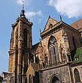
St Martin's Church, Colmar (Église Saint-Martin)
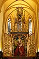
Martin Schongauer's Madonna of the Rose Bower inside the Église des Dominicains

The little Venice in Colmar (Haut-Rhin, France).

This building is inscrit au titre des monuments historiques de la France. It is indexed in the base Mérimée, a database of architectural heritage maintained by the French Ministry of Culture, under the reference

Colmar, France

This building is classé au titre des monuments historiques de la France. It is indexed in the base Mérimée, a database of architectural heritage maintained by the French Ministry of Culture, under the reference

A replica of The Little Vintner of Colmar by Frédéric Auguste Bartholdi, given by the town of Colmar to Princeton, its sister city, in 1988

Colmar: capital of Alsatian wines
.jpg)


.jpg)

Related pages
References
- ↑ "Commune de Colmar (68066)". Comparateur de territoire (in français). Institut national de la statistique et des études économiques - INSEE. Retrieved 22 December 2017.
- ↑ "City of Colmar". Map-France.com. Retrieved 22 December 2017.
- ↑ "Ville de Colmar". Annuaire-Mairie.fr (in français). Retrieved 22 December 2017.
- ↑ 4.0 4.1 "Colmar, France - Köppen Climate Classification". Weatherbase. Retrieved 14 December 2017.
- ↑ "Habitants du départment: Haut-Rhin" (in français). habitants.fr. Retrieved 22 December 2017.
- ↑ "Régions, départements, arrondissements, cantons et communes" (PDF). Populations légales 2014 (in français). Institut national de la statistique et des études économiques - INSEE. Retrieved 22 December 2017.
- ↑ "Unité urbaine de Colmar (68501)". Comparateur de territoire (in français). Institut national de la statistique et des études économiques - INSEE. Retrieved 22 December 2017.
- ↑ "Aire urbaine de Colmar (064)". Comparateur de territoire (in français). Institut national de la statistique et des études économiques - INSEE. Retrieved 22 December 2017.
- ↑ "Commune de Colmar (68066)". Géographie administrative et d’étude (in français). Institut national de la statistique et des études économiques - INSEE. Retrieved 23 December 2017.
- ↑ "Colmar et les villes jumelées". Ville de Colmar. Retrieved 23 December 2017.
Other websites
| Wikivoyage has a travel guide about: Colmar |