File:Östra Sjukhuset COVID-19 Fältsjukhus.jpg

Size of this preview: 800 × 557 pixels. Other resolutions: 320 × 223 pixels | 640 × 445 pixels | 1,024 × 713 pixels | 1,280 × 891 pixels | 3,373 × 2,347 pixels.
Original file (3,373 × 2,347 pixels, file size: 1.7 MB, MIME type: image/jpeg)
| This is a file from the Wikimedia Commons. The description on its description page there is shown below.
|
Summary
| Description |
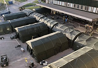
English: Field hospital constructed outside Östra Sjukhuset in Gothenburg in response to the 2020 COVID-19 pandemic. The tents contain a provisional intensive care unit.
Svenska: Fältsjukhus i tält på baksidan av Östra sjukhuset i Göteborg.
Försvarsmakten inledde bygget av fältsjukhuset måndag morgon 23 mars 2020 och från onsdag eftermiddag 25 mars stod det redo att ta emot sina första svårt sjuka coronapatienter till 20 tillfälliga intensivvårdsplatser utrustade med respiratorer om behovet av utökad intensivvårdskapacitet skulle uppstå. På Östra sjukhuset finns 12 ordinarie intensivvårdsplatser och totalt i hela Västragötandsregionen (år 2017) 115 ordinarie intensivvårdsplatser. |
| Date | |
| Source | CFCF |
| Author | Helén Sjöland |
| Camera location | | View this and other nearby images on: OpenStreetMap |
|---|
Licensing
This file is licensed under the Creative Commons Attribution-Share Alike 4.0 International license.
- You are free:
- to share – to copy, distribute and transmit the work
- to remix – to adapt the work
- Under the following conditions:
- attribution – You must give appropriate credit, provide a link to the license, and indicate if changes were made. You may do so in any reasonable manner, but not in any way that suggests the licensor endorses you or your use.
- share alike – If you remix, transform, or build upon the material, you must distribute your contributions under the same or compatible license as the original.
File history
Click on a date/time to view the file as it appeared at that time.
| Date/Time | Dimensions | User | Comment | |
|---|---|---|---|---|
| current | 08:25, 28 May 2021 | 3,373 × 2,347 (1.7 MB) | BuckeyeSmithie | Rotated and cropped to correct disorienting angle of original photo |
File usage
The following page uses this file: