File:13-09-29-nordfriesisches-wattenmeer-RalfR-15.jpg

Size of this preview: 800 × 531 pixels. Other resolutions: 320 × 213 pixels | 640 × 425 pixels | 1,024 × 680 pixels | 1,280 × 850 pixels | 4,288 × 2,848 pixels.
Original file (4,288 × 2,848 pixels, file size: 5.75 MB, MIME type: image/jpeg)
| This is a file from the Wikimedia Commons. The description on its description page there is shown below.
|
Summary
| Description |
Català: Neuwerk illa al Mar de Wadden al Mar del Nord, Alemanya
Čeština: Neuwerk ostrov v moři Wadden do Severního moře, Německo
Dansk: Neuwerk ø i Vadehavet til Vesterhavet, Tyskland
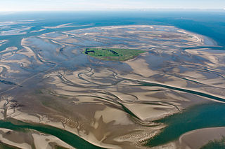
Deutsch: Fotoflug über das nordfriesische Wattenmeer; Blick von OSO aus 1,4 km Höhe und 6 km Entfernung auf Neuwerk. Links sind die Pferdefuhrwerke im Watt erkennbar.
English: Island Neuwerk near Hamburg in the German Wadden Sea. View from ESE, from 1400 m height and 6 km distance.
Español: Neuwerk isla en el Mar de Wadden en el Mar del Norte, Alemania
Suomi: Neuwerk saari Waddenzeen Pohjanmeren, Saksa
Русский: Ваттовое море у берегов Германии. Зелёный остров Нойверк с маяком (1369), за ним остров Шархёрн - птичий заповедник.
Українська: Ваттове море біля берегів Німеччини. Зелений острів Нойверк з маяком (1369), за ним острів Шархьорн - пташиний заповідник. |
|||||||||||||||||||||||
| Date | ||||||||||||||||||||||||
| Source | Own work | |||||||||||||||||||||||
| Author |
|
|||||||||||||||||||||||
| Other versions | ||||||||||||||||||||||||
| Camera location | | View this and other nearby images on: OpenStreetMap |
|---|
|
This image was selected as picture of the day on Wikimedia Commons for 24 March 2014. It was captioned as follows: English: Island Neuwerk near Hamburg in the german wadden Sea; View from ESE and a high of 4600 feet and distance of 20.000 feet. Other languages:
Bosanski: Ostrvo Neuwerk blizu Hamburga na njemačkoj obali Sjevernog mora (Wattensee); Pogled iz pravca istok-sjeveroistok sa visine 1.400 metara i udaljenosti 6.000 metara. English: Island Neuwerk near Hamburg in the german wadden Sea; View from ESE and a high of 4600 feet and distance of 20.000 feet. Italiano: Isola di Neuwerk vicino ad Amburgo nel mare dei Wadden; Vista da ESE da un'altezza di 1,5 km e una distanza di 6 km. Magyar: Neuwerk sziget Hamburg közelében a német Watt-tengeren kelet-délkelet felől nézve, 4600 láb (1,4 km) magasból és 20 000 láb (6,1 km) távolságból Nederlands: Het Waddeneiland Neuwerk bij Cuxhaven in het Duitse gedeelte van de Waddenzee, gezien vanaf een hoogte van 4600 voet en een afstand van 20.000 voet. 한국어: 독일 바덴 해, 함부르크 근교의 노이베르크 섬. 동남동 방향에서 고도 4600 피트, 거리 20000 피트에서 촬영. 中文: 瓦登海诺伊韦克岛。 |
Licensing
I, the copyright holder of this work, hereby publish it under the following licenses:

|
Permission is granted to copy, distribute and/or modify this document under the terms of the GNU Free Documentation License, Version 1.2 or any later version published by the Free Software Foundation; with no Invariant Sections, no Front-Cover Texts, and no Back-Cover Texts. A copy of the license is included in the section entitled GNU Free Documentation License. |
This file is licensed under the Creative Commons Attribution-Share Alike 3.0 Unported, 2.5 Generic, 2.0 Generic and 1.0 Generic license.
- You are free:
- to share – to copy, distribute and transmit the work
- to remix – to adapt the work
- Under the following conditions:
- attribution – You must give appropriate credit, provide a link to the license, and indicate if changes were made. You may do so in any reasonable manner, but not in any way that suggests the licensor endorses you or your use.
- share alike – If you remix, transform, or build upon the material, you must distribute your contributions under the same or compatible license as the original.
You may select the license of your choice.

- Weiternutzung dieses Fotos
- Wenn Sie dieses Foto im Internet verwenden möchten, bitte ich um Verlinkung meiner privaten Homepage: www.fahrradmonteur.de.
Sie können das Bild unter einer der unten angegebenen Lizenzen frei verwenden, dabei ist keine Gebühr zu entrichten. Eine kommerzielle Verwendung dieses Fotos ist ebenfalls möglich, dabei sind außer den u. g. Lizenzbestimmungen keine gesonderten Bedingungen zu beachten.
| Ralf Roletschek
(1963–) |
|||
|---|---|---|---|
 |
|||
| Description | German civil engineer and photographer | ||
| Date of birth |
1963 | ||
| Location of birth | Eberswalde | ||
| Work period | from 1979 | ||
| Work location |
Barcelona, Wien, Eberswalde | ||
| Authority file | |||
| Dieses Foto entstand aufgrund eines Projektes, das von Wikimedia Deutschland e. V. gefördert wurde.
Im Rahmen des „Community-Projektbudgets“ sollen Luftbilder u.a. von Inseln, Halligen, Sanden und Küstenstädten der deutschen Nordseeküste angefertigt werden. Das Projekt „Fotoflüge“ wurde im September 2011 begonnen. |
| Annotations | This image is annotated: View the annotations at Commons |
File history
Click on a date/time to view the file as it appeared at that time.
| Date/Time | Dimensions | User | Comment | |
|---|---|---|---|---|
| current | 02:38, 14 October 2013 | 4,288 × 2,848 (5.75 MB) | Ralf Roletschek | leicht gedreht, CA gemildert |
File usage
The following page uses this file: