File:A Vörös és a Kék kápolnák közötti sétány kerti lugassal, gabion támfalrendszerrel, 2018 Balatonboglár.jpg

Size of this preview: 800 × 600 pixels. Other resolutions: 320 × 240 pixels | 640 × 480 pixels | 1,024 × 768 pixels | 1,280 × 960 pixels | 2,221 × 1,665 pixels.
Original file (2,221 × 1,665 pixels, file size: 1.27 MB, MIME type: image/jpeg)
| This is a file from the Wikimedia Commons. The description on its description page there is shown below.
|
Summary
| Description |
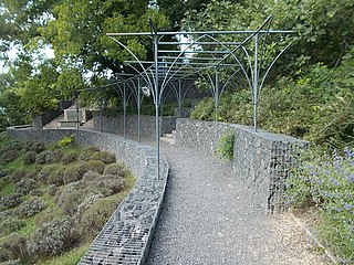
English: : Walkway and retaining walls between Red and Blue Chapels on the Kápolna hill, now called it Szent Erzsébet Park [1], Balatonboglár, Somogy County, Hungary.
Magyar: : A Vörös és a Kék kápolnák közötti parkrész (kertépítész-tervezőa Magyar Tájépítészek Szövetségének az elnöke, Dömötör Tamás [2] tervei alapján 2012-ben készült) " Pezsgős támfal,-LA Hippocampus alkotótábor alkotása és a gabion támfalrendszer része, -nem pusztán a löszfalak suvadásveszélye miatt, vagy a tanúhegyeket megidéző bazalt töltelék miatt érdekes, hanem az éjjel díszvilágítás funkciót is betöltő homokfúvott pezsgőspalack betétek miatt is, amelyek a BB pezsgő balatonboglári gyártásának állítanak emléket ". [3] - Somogy megye, Balatonboglár, Temető domb, Kápolna domb, legújabban Szent Erzsébet park. |
| Date | |
| Source | Own work |
| Author | Globetrotter19 |
| Object location | | View this and other nearby images on: OpenStreetMap |
|---|
| Camera location | | View this and other nearby images on: OpenStreetMap |
|---|
Licensing
I, the copyright holder of this work, hereby publish it under the following license:
This file is licensed under the Creative Commons Attribution-Share Alike 3.0 Unported license.
- You are free:
- to share – to copy, distribute and transmit the work
- to remix – to adapt the work
- Under the following conditions:
- attribution – You must give appropriate credit, provide a link to the license, and indicate if changes were made. You may do so in any reasonable manner, but not in any way that suggests the licensor endorses you or your use.
- share alike – If you remix, transform, or build upon the material, you must distribute your contributions under the same or compatible license as the original.
| Annotations | This image is annotated: View the annotations at Commons |
File history
Click on a date/time to view the file as it appeared at that time.
| Date/Time | Dimensions | User | Comment | |
|---|---|---|---|---|
| current | 15:17, 23 October 2018 | 2,221 × 1,665 (1.27 MB) | Globetrotter19 | User created page with UploadWizard |
File usage
The following page uses this file: