File:Aerial image of Passau.jpg

Size of this preview: 800 × 533 pixels. Other resolutions: 320 × 213 pixels | 640 × 427 pixels | 1,024 × 683 pixels | 1,280 × 853 pixels | 5,400 × 3,600 pixels.
Original file (5,400 × 3,600 pixels, file size: 6.47 MB, MIME type: image/jpeg)
| This is a file from the Wikimedia Commons. The description on its description page there is shown below.
|
Summary
| Description |
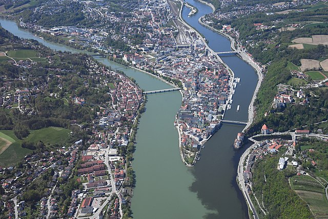
English: Aerial image of Passau showing the old town and the confluence of the Inn, Danube, and Ilz rivers (from left to right)
Deutsch: Luftbild von Passau, das die Altstadt sowie den Zusammenfluss des Inns, der Donau und der Ilz (von links nach rechts) zeigt |
| Date | |
| Source | Own work |
| Author | Carsten Steger |
| Camera location | | View this and other nearby images on: OpenStreetMap |
|---|
| Object location | | View this and other nearby images on: OpenStreetMap |
|---|
Licensing
I, the copyright holder of this work, hereby publish it under the following license:
This file is licensed under the Creative Commons Attribution-Share Alike 4.0 International license.
- You are free:
- to share – to copy, distribute and transmit the work
- to remix – to adapt the work
- Under the following conditions:
- attribution – You must give appropriate credit, provide a link to the license, and indicate if changes were made. You may do so in any reasonable manner, but not in any way that suggests the licensor endorses you or your use.
- share alike – If you remix, transform, or build upon the material, you must distribute your contributions under the same or compatible license as the original.
This image has been assessed using the Quality image guidelines and is considered a Quality image.
|
File history
Click on a date/time to view the file as it appeared at that time.
| Date/Time | Dimensions | User | Comment | |
|---|---|---|---|---|
| current | 08:21, 13 May 2021 | 5,400 × 3,600 (6.47 MB) | Carsten Steger | Uploaded own work with UploadWizard |