File:Amarnamap.png

Size of this preview: 772 × 599 pixels. Other resolutions: 309 × 240 pixels | 619 × 480 pixels | 782 × 607 pixels.
Original file (782 × 607 pixels, file size: 743 KB, MIME type: image/png)
| This is a file from the Wikimedia Commons. The description on its description page there is shown below.
|
Summary
| Description |
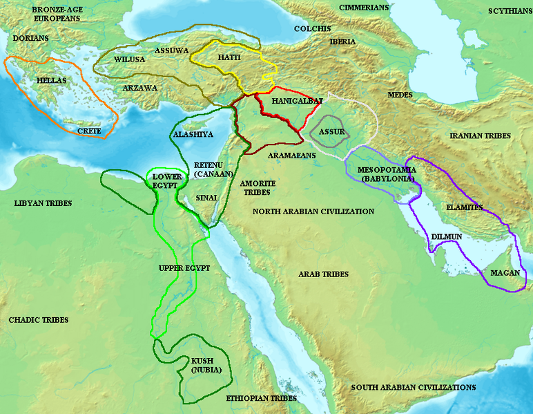
English: Map of the ancient Near East during the Amarna period, showing the great powers of the period: Egypt (green), Hatti (yellow), the Kassite kingdom of Babylon (purple), Assyria (grey), and Mittani (red). Lighter areas show direct control, darker areas represent spheres of influence. The extent of the Achaean/Mycenaean civilization is shown in orange.
On the map above: the territory between Medes and Iberia was called Ararat or Armenia, around the lake Van.
Русский: Карта Восточного Средиземноморья в Амарнский период (XIV век до н. э.). Территория Египта обведена зелёным, Митанни — красным, Хатти — жёлтым (покорённые ими территории обозначены более тёмными контурами того же цвета). |
||
| Date | |||
| Source |
|
||
| Author | Briangotts |

Licensing
I, the copyright holder of this work, hereby publish it under the following license:

|
Permission is granted to copy, distribute and/or modify this document under the terms of the GNU Free Documentation License, Version 1.2 or any later version published by the Free Software Foundation; with no Invariant Sections, no Front-Cover Texts, and no Back-Cover Texts. A copy of the license is included in the section entitled GNU Free Documentation License. |
| This file is licensed under the Creative Commons Attribution-Share Alike 3.0 Unported license. | ||
| ||
| This licensing tag was added to this file as part of the GFDL licensing update. |
File history
Click on a date/time to view the file as it appeared at that time.
| Date/Time | Dimensions | User | Comment | |
|---|---|---|---|---|
| current | 02:55, 3 December 2006 | 782 × 607 (743 KB) | Electionworld | {{ew|en|Briangotts}} Map of the ancient Near East during the Amarna period, showing the great powers of the period: Egypt (green), Hatti (yellow), the Kassite kingdom of Babylon (purple), Assyria (grey), and Mittani (red). |
File usage
The following page uses this file: