File:Bearing and azimuth along the geodesic.png

Size of this preview: 474 × 600 pixels. Other resolutions: 189 × 240 pixels | 632 × 800 pixels.
Original file (632 × 800 pixels, file size: 87 KB, MIME type: image/png)
| This is a file from the Wikimedia Commons. The description on its description page there is shown below.
|
Summary
| Description |
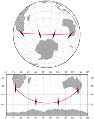
English: The bearing and azimuth between Cape Town and Melbourne along the geodesic (the shortest route) change from 141° to 42°. Azimuthal orthographic projection (the upper map) and Miller cylindrical projection (the lower map). The map was created using the Generic Mapping Tools, GMT, version 5.1.1. |
| Date | |
| Source |
Own work |
| Author | Darekk2 |
Licensing
I, the copyright holder of this work, hereby publish it under the following license:
This file is licensed under the Creative Commons Attribution-Share Alike 4.0 International license.
- You are free:
- to share – to copy, distribute and transmit the work
- to remix – to adapt the work
- Under the following conditions:
- attribution – You must give appropriate credit, provide a link to the license, and indicate if changes were made. You may do so in any reasonable manner, but not in any way that suggests the licensor endorses you or your use.
- share alike – If you remix, transform, or build upon the material, you must distribute your contributions under the same or compatible license as the original.
File history
Click on a date/time to view the file as it appeared at that time.
| Date/Time | Dimensions | User | Comment | |
|---|---|---|---|---|
| current | 15:28, 1 March 2015 | 632 × 800 (87 KB) | Darekk2 | User created page with UploadWizard |
File usage
The following page uses this file: