File:Bf-map names SE.png
No higher resolution available.
Bf-map_names_SE.png (330 × 355 pixels, file size: 20 KB, MIME type: image/png)
| This is a file from the Wikimedia Commons. The description on its description page there is shown below.
|
Summary
| Description |
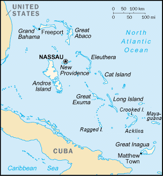
English: Map of the Bahamas |
| Date | 18 September 2004 (original upload date) |
| Source | From File:Bf-map.gif with more islands identified in the SE sector. |
| Author | Keith Edkins at English Wikipedia |
Licensing
Keith Edkins at the English-language Wikipedia, the copyright holder of this work, hereby publishes it under the following license:
| This file is licensed under the Creative Commons Attribution-Share Alike 3.0 Unported license. Subject to disclaimers. | ||
| Attribution: Keith Edkins at the English-language Wikipedia | ||
| ||
| This licensing tag was added to this file as part of the GFDL licensing update. |

|
Permission is granted to copy, distribute and/or modify this document under the terms of the GNU Free Documentation License, Version 1.2 or any later version published by the Free Software Foundation; with no Invariant Sections, no Front-Cover Texts, and no Back-Cover Texts. A copy of the license is included in the section entitled GNU Free Documentation License. Subject to disclaimers. |
Original upload log
Transferred from en.wikipedia to Commons by Jóna Þórunn.
The original description page was here. All following user names refer to en.wikipedia.
- 2004-09-19 08:05 Keith Edkins 330×355×8 (20239 bytes)
- 2004-09-18 16:14 Keith Edkins 330×355×8 (19672 bytes)
File history
Click on a date/time to view the file as it appeared at that time.
| Date/Time | Dimensions | User | Comment | |
|---|---|---|---|---|
| current | 16:15, 10 May 2008 | 330 × 355 (20 KB) | File Upload Bot (Magnus Manske) | {{BotMoveToCommons|en.wikipedia}} {{Information |Description={{en|From en::Image:Bf-map.gif with more islands identified in the SE sector.}} |Source=Transferred from [http://en.wikipedia.org en.wikipedia]; Transfer was stated to be made by [[User:J� |
File usage
The following 2 pages use this file: