File:Bielsko-Biała Language Island.png

Original file (1,748 × 1,368 pixels, file size: 2.58 MB, MIME type: image/png)
| This is a file from the Wikimedia Commons. The description on its description page there is shown below.
|
Summary
| Description |
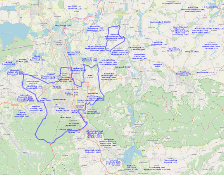
English: Bielsko-Biała German language island before WW2 (blue line), with some possible Walddeutsche settlements from the middle ages and later. The red line is the border between Silesia and Lesser Poland since the early 16th. Modern Bielsko-Biała borders in pink.
Based on File:GermanHamletsSince15th.jpg and de:Liste mittelalterlicher Walddeutscher Siedlungen and [1], also: Robert Mrózek, Nazwy miejscowe Śląska Cieszyńskiego, 1984, and others. It is important to note that many of the mentions in German or Latin (which could indicate mixed population) were ephemeral or with only a singular occurence among numerous Slavic/Polish mentions [maybe because the scribe in Auschwitz/Oświęcim was German at the moment, or the ruler of a Slavic village was a German nobleman]. The Kurt Lück's map from 1934 was obviously exaggerated.Polski: Bielska wyspa językowa przed wojną (linia niebieska), plus możliwe osady niemieckie lub (częściej) mieszane ze średniowiecza i późniejsze (po stronie śląskiej była np. kolejna fala osadnictwa niemieckiego w 3 ćwierci XV wieku na obszarze osadnictwa słowiańskiego). Linia czerwona to granica polsko-śląska po nabyciu księstwa oświęcimskiego przez Polskę. Na rużowo granice Bielska-Białej.
Źródła: File:GermanHamletsSince15th.jpg, de:Liste mittelalterlicher Walddeutscher Siedlungen i [2], też: Robert Mrózek, Nazwy miejscowe Śląska Cieszyńskiego, 1984, i inne. Trzeba zauważyć, że często jedynym źródłem o narodowości mieszkańców wsi jest zapis nazwy, konsekwentne używanie niemieckiej nazwy w źródłach sugeruje osadnictwo niemieckie, mieszane lub łacińskie osadnictwo mieszane, większość z nazw niemieckich na wschód od Bielska były efemeryczne, często jednorazowe, co równie dobrze mogło być przez niemieckiego skrybę w Oświęcimiu, albo właścicielem był akurat Niemiec, choć w obu przypadkach mieszkańcy mogli być polscy. Mapa Karta Lücka z 1934 jest oczywiście przesadzona. |
| Date | |
| Source | Own work |
| Author | D T G |
Licensing
- You are free:
- to share – to copy, distribute and transmit the work
- to remix – to adapt the work
- Under the following conditions:
- attribution – You must give appropriate credit, provide a link to the license, and indicate if changes were made. You may do so in any reasonable manner, but not in any way that suggests the licensor endorses you or your use.
- share alike – If you remix, transform, or build upon the material, you must distribute your contributions under the same or compatible license as the original.
| This work contains information from OpenStreetMap, which is made available under the Open Database License (ODbL).
The ODbL does not require any particular license for maps produced from ODbL data. Prior to 1 August 2020, map tiles produced by the OpenStreetMap Foundation were licensed under the CC-BY-SA-2.0 license. Maps produced by other people may be subject to other licences. |
File history
Click on a date/time to view the file as it appeared at that time.
| Date/Time | Dimensions | User | Comment | |
|---|---|---|---|---|
| current | 06:59, 18 January 2019 | 1,748 × 1,368 (2.58 MB) | D T G | more mentions |
File usage
The following page uses this file: