File:Bryce Amphitheater from Sunrise Point Highres 2013.jpg

Original file (19,709 × 6,688 pixels, file size: 74.69 MB, MIME type: image/jpeg)
| This is a file from the Wikimedia Commons. The description on its description page there is shown below.
|
Summary
| Warning | The original file is very high-resolution. It might not load properly or could cause your browser to freeze when opened at full size. |
|---|
| Description |
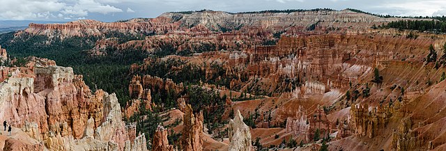
Deutsch: Hochauflösendes Panorama des Bryce Canyon Amphitheater fotografiert vom Sunrise Point English: High resolution panoramic view of Bryce Canyon Amphitheater photographed from the Sunrise Point Français : Vue panoramique haute résolution du Bryce Canyon Amphitheater photographié depuis Sunrise Point |
| Date | Taken on 10 September 2013, 16:08:37 |
| Source | Own work |
| Author | Tuxyso |
| Attribution (required by the license) | Tuxyso / Wikimedia Commons / |
| Camera location | | View this and other nearby images on: OpenStreetMap |
|---|
Licensing
- You are free:
- to share – to copy, distribute and transmit the work
- to remix – to adapt the work
- Under the following conditions:
- attribution – You must give appropriate credit, provide a link to the license, and indicate if changes were made. You may do so in any reasonable manner, but not in any way that suggests the licensor endorses you or your use.
- share alike – If you remix, transform, or build upon the material, you must distribute your contributions under the same or compatible license as the original.
|
Dieses Foto ist vom Wikimedia Commons Nutzer Tuxyso. Achtung: Dieses Bild ist nicht gemeinfrei. Es ist zwar frei benutzbar aber gesetzlich geschützt. |
This photo was created by Wikimedia Commons user Tuxyso. Note: this image is not in the Public Domain. It is free to use but protected by law. |
||
|
|
Bitte benutzen sie nach Möglichkeit in der Bildbeschreibung: Tuxyso / Wikimedia Commons / CC-BY-SA-3.0 in unmittelbarer Nähe beim Bild oder an einer Stelle in ihrer Publikation, wo dies üblich ist. Dabei muß der Zusammenhang zwischen Bild und Urhebernennung gewahrt bleiben. |
I prefer the following credit: Tuxyso / Wikimedia Commons / CC-BY-SA-3.0 near to the photo or at a location that is common in your publication but preserving the association between image and credit. |
 |
|
Bitte lesen sie den Lizenztext gründlich, bevor sie das Bild nutzen! Wenn sie Fragen zu den Lizenzvereinbarungen haben oder mich auf eine interessante Nachnutzung hinweisen möchten, kontaktieren sie mich bitte per Mail: tuxyso@gmail.com. |
Please review the license requirements carefully before using this image. If you would like to clarify the license terms or inform me about a reuse of the image (which is always interesting for me), please contact me by email: tuxyso@gmail.com. |
||

|
This image was selected as picture of the day on Wikimedia Commons for 11 February 2014. It was captioned as follows: English: High resolution panoramic view of Bryce Canyon Amphitheater photographed from the Sunrise Point Other languages:
Bosanski: Panoramski pogled visoke rezolucije na prirodni amfiteatar u kanjonu Bryce Čeština: Pohled na část Národního parku Spojených států amerických jménem Bryce Canyon Amphitheater z místa Sunrise Point. Panoramatický snímek ve vysokém rozlišení. Deutsch: Hochauflösendes Panorama des Bryce Canyon Amphitheater fotografiert vom Sunrise Point English: High resolution panoramic view of Bryce Canyon Amphitheater photographed from the Sunrise Point Italiano: Foto panoramica in alta risoluzione dell'anfiteatro del Bryce Canyon fotografato da Sunrise Point Magyar: A Bryce Canyon Amfiteátrumról készített nagyfelbontású panoráma a Sunrise Point felől Русский: Панорама национального парка Брайс-Каньон (Юта). 中文: 美国布莱斯峡谷国家公园圆形剧场全景图。 |

|
NOTE: This image is a panorama of :Bryce Amphitheater consisting of 39 frames that were merged or stitched in Hugin 2012.0. As a result, this image necessarily underwent some form of digital manipulation. These manipulations may include blending, blurring, cloning, and colour and perspective adjustments. As a result of these adjustments, the image content may be slightly different from reality at the points where multiple images were combined. This manipulation is often required due to lens, perspective, and parallax distortions.
|
This image has been assessed using the Quality image guidelines and is considered a Quality image.
|
File history
Click on a date/time to view the file as it appeared at that time.
| Date/Time | Dimensions | User | Comment | |
|---|---|---|---|---|
| current | 01:40, 25 September 2013 | 19,709 × 6,688 (74.69 MB) | Tuxyso | Slight CCW rotation |
File usage
The following 2 pages use this file: