File:Carte Skagerrak-Kattegat2.png
No higher resolution available.
Carte_Skagerrak-Kattegat2.png (445 × 508 pixels, file size: 15 KB, MIME type: image/png)
| This is a file from the Wikimedia Commons. The description on its description page there is shown below.
|
Summary
| Description |
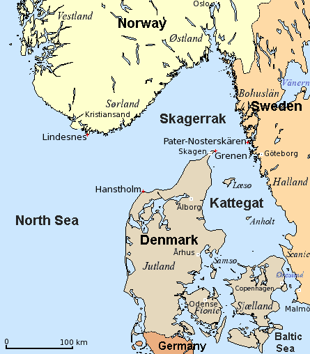
English: Map of Skagerrak and Kattegat — straits/bays of the North Sea, along Denmark, Norway, and Sweden.
Dansk: Kort over Skagerrak og Kattegat (Danmark, Norge, Sverige).
Deutsch: Karte von Skagerrak und Kattegat (Dänemark, Norwegen, Schweden).
Français : Carte du Skagerrak et du Kattegat (Danemark, Norvège, Suède).
|
| Date | 8 December 2006 (original upload date) |
| Source |
English: Modification of
Dansk: Bearbejdelse af
Deutsch: Bearbeitung von
File:Carte_Skagerrak-Kattegat.png |
| Author | The original uploader was Attilios at English Wikipedia. |
| Other versions |
|


Licensing
| This file is licensed under the Creative Commons Attribution-Share Alike 3.0 Unported license. Subject to disclaimers. | ||
| ||
| This licensing tag was added to this file as part of the GFDL licensing update. |

|
Permission is granted to copy, distribute and/or modify this document under the terms of the GNU Free Documentation License, Version 1.2 or any later version published by the Free Software Foundation; with no Invariant Sections, no Front-Cover Texts, and no Back-Cover Texts. A copy of the license is included in the section entitled GNU Free Documentation License. Subject to disclaimers. |
Original upload log
Transferred from en.wikipedia to Commons by Smooth_O using CommonsHelper.
The original description page was here. All following user names refer to en.wikipedia.
- 2006-12-08 19:07 Attilios 445×508×4 (15028 bytes) Modification of Carte_Skagerrak-Kattegat.png {{GFDL}}
File history
Click on a date/time to view the file as it appeared at that time.
| Date/Time | Dimensions | User | Comment | |
|---|---|---|---|---|
| current | 11:50, 6 March 2018 | 445 × 508 (15 KB) | Hohum | Cartographic colours, nations. |
File usage
The following page uses this file: