File:Colonization 1945.png
Original file(1,438 × 638 pixels, file size: 85 KB, MIME type: image/png)

Commons-logo.svg This is a file from the Wikimedia Commons. The description on its description page there is shown below.
Commons is a freely licensed media file repository. You can help.
This historical map image could be re-created using vector graphics as an SVG file. This has several advantages; see Commons:Media for cleanup for more information. If an SVG form of this image is available, please upload it and afterwards replace this template with {{vector version available|new image name}}.


It is recommended to name the SVG file “Colonization 1945.svg”—then the template Vector version available (or Vva) does not need the new image name parameter.

Summary

Description
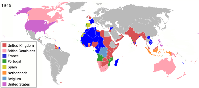
English: The colors represent the colonies of various nations in 1945, and the colonial borders of that time.
Français : Les couleurs représentent les colonies des diverses pays en 1945 et les frontières coloniales de l'époque.
Español: Colonialismo en 1945
한국어: 1945년 다양한 국가의 식민지들 및 당시 식민지의 경계
Date (unknown)
Source File:Colonisation2.gif
Author en:User:Aris Katsaris
Permission
(Reusing this file)
w:en:Creative Commons
attribution share alike
This file is licensed under the Creative Commons Attribution-Share Alike 3.0 Unported license.
You are free:
  • to share – to copy, distribute and transmit the work
  • to remix – to adapt the work
Under the following conditions:
  • attribution – You must give appropriate credit, provide a link to the license, and indicate if changes were made. You may do so in any reasonable manner, but not in any way that suggests the licensor endorses you or your use.
  • share alike – If you remix, transform, or build upon the material, you must distribute your contributions under the same or compatible license as the original.
Other versions

See also

Maps of world history
BC

5000 · 2000 · 1000 · 500 · 400 · 323 · 300 · 200 · 100 · 50


AD

1 · 50 · 100 · 200 · 250 · 300 · 400 · 500 · 700 · 750 · 820 · 900 · 1200 · 1500 · 1556 · 1648 · 1700 · 1750 · 1815 · 1859 · 1871 · 1914 · 1989 · 2000 ·


Maps of colonization history
1492 · 1550 · 1600 · 1660 · 1754 · 1800 · 1812 · 1822 · 1885 · 1898 · 1914 · 1920 · 1936 · 1938 · 1945 · 1959 · 1974 · 1975 · 2007
Animated Map

Maps of Cold War
1959 · 1980 · Nows ·

see also: Eastern Hemisphere only maps template (1300BC-1500AD)

(this template: · view · discuss )

Captions

Colonization of different countries in 1945, same colonial borders at that time.

Items portrayed in this file

depicts

image/png

b8a9bea6065a0f3d02b5cfb8346b751307af6d7d

87,393 byte

638 pixel

1,438 pixel

File history

Click on a date/time to view the file as it appeared at that time.

Date/TimeDimensionsUserComment
current10:20, 28 June 20191,438 × 638 (85 KB)Andres.tvRecovering the large size of the image and improving the color for France.

The following 4 pages use this file:

Metadata