File:Cyclades-Satellite.png

Size of this preview: 661 × 600 pixels. Other resolutions: 265 × 240 pixels | 529 × 480 pixels | 846 × 768 pixels | 1,129 × 1,024 pixels | 1,965 × 1,783 pixels.
Original file (1,965 × 1,783 pixels, file size: 1.83 MB, MIME type: image/png)
| This is a file from the Wikimedia Commons. The description on its description page there is shown below.
|
Summary
| Description | |
| Date | 25 July 2007 (original upload date) |
| Source |
|
| Author | Henryhartley at en.wikipedia |
| Permission (Reusing this file) |
Since the satellite image is originally a NASA image, I believe this is a legal use. |
Licensing
Henryhartley at the English Wikipedia, the copyright holder of this work, hereby publishes it under the following license:

|
Permission is granted to copy, distribute and/or modify this document under the terms of the GNU Free Documentation License, Version 1.2 or any later version published by the Free Software Foundation; with no Invariant Sections, no Front-Cover Texts, and no Back-Cover Texts. A copy of the license is included in the section entitled GNU Free Documentation License. |
Original upload log
The original description page was here. All following user names refer to en.wikipedia.
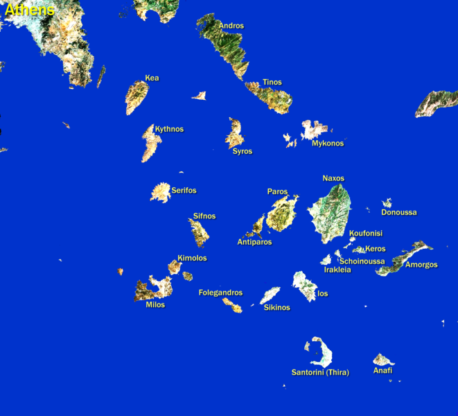
- 2007-07-25 18:41 Henryhartley 1965×1783× (1922903 bytes) Satellite image as used by Google Maps but modified by removing sea, brightening land, and adding island names. Since the satellite image is originally a NASA image, I believe this is a legal use. All modifications are by me.
File history
Click on a date/time to view the file as it appeared at that time.
| Date/Time | Dimensions | User | Comment | |
|---|---|---|---|---|
| current | 18:12, 10 April 2012 | 1,965 × 1,783 (1.83 MB) | OgreBot | (BOT): Uploading old version of file from en.wikipedia; originally uploaded on 2007-07-25 18:41:32 by Henryhartley |
File usage
The following page uses this file: