File:DEM Baikal lake.png

Size of this preview: 800 × 572 pixels. Other resolutions: 320 × 229 pixels | 640 × 457 pixels | 1,024 × 732 pixels | 1,280 × 915 pixels | 3,337 × 2,385 pixels.
Original file (3,337 × 2,385 pixels, file size: 4.49 MB, MIME type: image/png)
| This is a file from the Wikimedia Commons. The description on its description page there is shown below.
|
| Description |
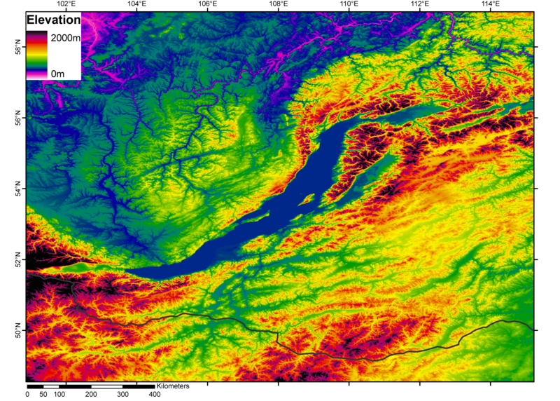
Čeština: DEM Bajkalského jezera. Černá čára je Rusko-mongolská hranice.
English: Digital elevation model (DEM) of Lake Baikal. The black line is the Russia-Mongolia boundary. |
| Source | from the GLOBE dataset (http://www.ngdc.noaa.gov/mgg/topo/globega2.html) |
| Author | processed with Arcgis 9.1 by Jide |
| Permission (Reusing this file) |
I, the copyright holder of this work, hereby publish it under the following license: This file is licensed under the Creative Commons Attribution-Share Alike 2.5 Generic license.
|
File history
Click on a date/time to view the file as it appeared at that time.
| Date/Time | Dimensions | User | Comment | |
|---|---|---|---|---|
| current | 17:01, 2 November 2006 | 3,337 × 2,385 (4.49 MB) | Jide~commonswiki | DEM from the GLOBE dataset (http://www.ngdc.noaa.gov/mgg/topo/globega2.html) processed with Arcgis 9.1 by ~~~. The black line is the Russia-Mongolia boundary. |
File usage
The following page uses this file: