File:Dane county.png
No higher resolution available.
Dane_county.png (594 × 439 pixels, file size: 125 KB, MIME type: image/png)
| This is a file from the Wikimedia Commons. The description on its description page there is shown below.
|
Summary
| Description |
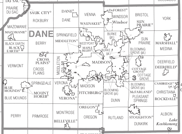
English: This is a map of Dane County, Wisconsin, that shows all the municipalities (city, town, and village).
I took this from a larger file, U.S. Census Bureau, Census 2000, maps of Wisconsin. |
| Source | http://www2.census.gov/geo/maps/general_ref/cousub_outline/cen2k_pgsz/wi_cosub.pdf |
| Author | United States Census Bureau |
Licensing
This image or file is a work of a United States Census Bureau employee, taken or made as part of that person's official duties. As a work of the U.S. federal government, the image is in the public domain.
|
 |
Original upload log
The original description page was here. All following user names refer to en.wikipedia.
| Date/Time | Dimensions | User | Comment |
|---|---|---|---|
| 2006-06-14 19:09 | 594×439× (128020 bytes) | Hal Canary | This is a map of Dane County, Wisconsin, that shows all the municipalities (city, town, and villiage). I took this from a larger file, [U.S. Census Bureau, Census 2000, maps of Wisconsin|http://ftp2.census.gov/geo/maps/general_ref/cousub_outline/cen2k_pg |
File history
Click on a date/time to view the file as it appeared at that time.
| Date/Time | Dimensions | User | Comment | |
|---|---|---|---|---|
| current | 11:49, 5 March 2016 | 594 × 439 (125 KB) | Kingofthedead | Transferred from en.wikipedia |
File usage
The following page uses this file: