File:Detail from a French map, published 1755, showing the Chicago Portage.jpg
No higher resolution available.
Detail_from_a_French_map,_published_1755,_showing_the_Chicago_Portage.jpg (425 × 332 pixels, file size: 97 KB, MIME type: image/jpeg)
| This is a file from the Wikimedia Commons. The description on its description page there is shown below.
|
Summary
| Description |
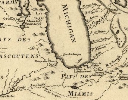
English: Detail from a map entitled "Partie occidentale de la Nouvelle France ou du Canada", published in 1755, that shows the “Portage des Chenes” (the portage of oak trees), that later became known as the Chicago Portage. |
| Date | |
| Source | https://www.loc.gov/resource/g3310.ar001900/?r=-0.373,-0.012,1.749,0.868,0 |
| Author | Jacques Nicolas Bellin |
Licensing
This work is in the public domain in the United States because it was published (or registered with the U.S. Copyright Office) before January 1, 1929.
Public domain works must be out of copyright in both the United States and in the source country of the work in order to be hosted on the Commons. If the work is not a U.S. work, the file must have an additional copyright tag indicating the copyright status in the source country.
Note: This tag should not be used for sound recordings. |
File history
Click on a date/time to view the file as it appeared at that time.
| Date/Time | Dimensions | User | Comment | |
|---|---|---|---|---|
| current | 09:40, 26 October 2020 | 425 × 332 (97 KB) | Joe Bfsplk | Uploaded a work by Jacques Nicolas Bellin from https://www.loc.gov/resource/g3310.ar001900/?r=-0.373,-0.012,1.749,0.868,0 with UploadWizard |
File usage
The following page uses this file: