File:Dnipro estuary.jpg
Original file (3,509 × 4,724 pixels, file size: 10.21 MB, MIME type: image/jpeg)
| This is a file from the Wikimedia Commons. The description on its description page there is shown below.
|
Summary
| Description |
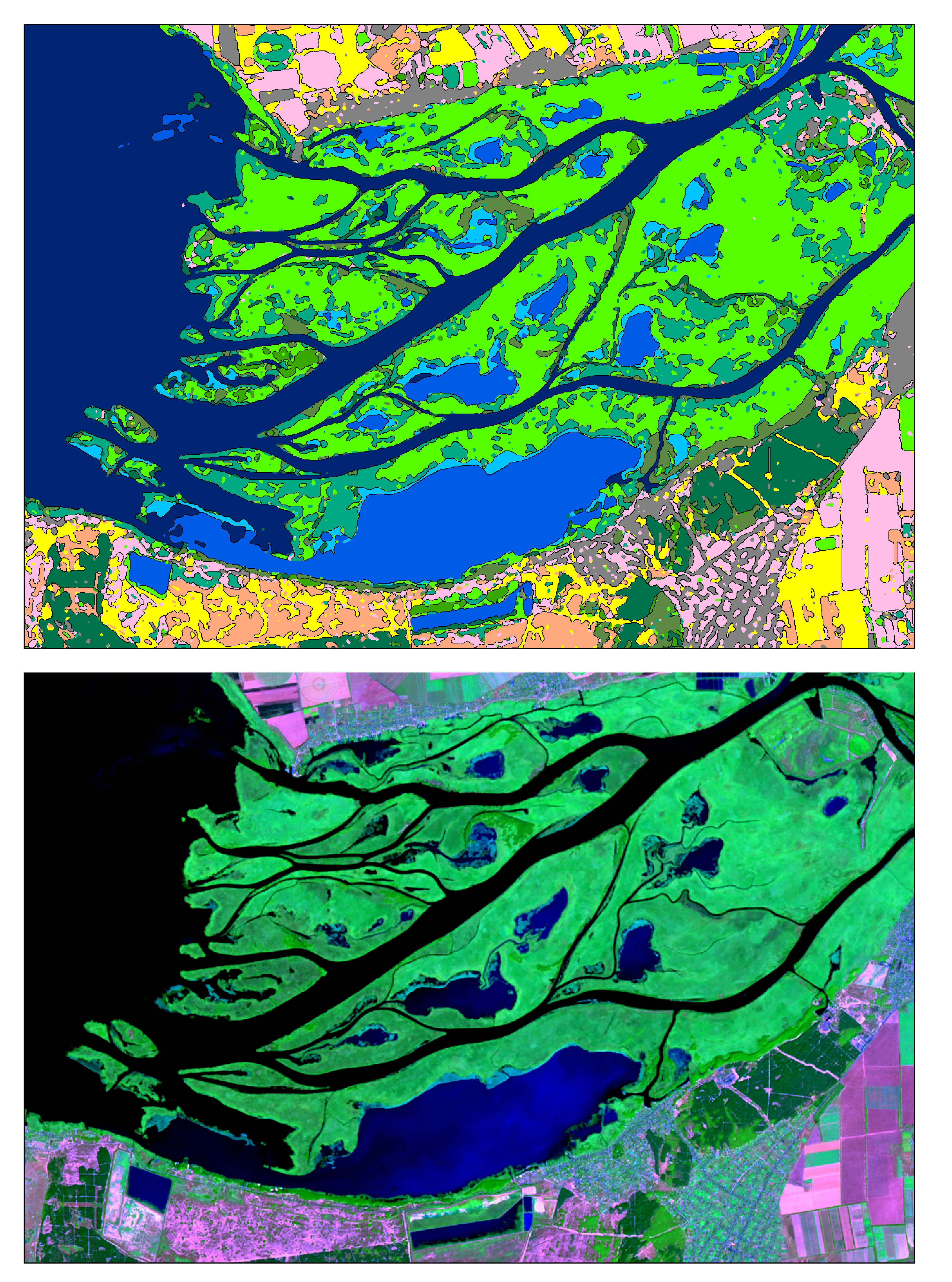
Українська: Cупутниковий знімок гирла р. Дніпро, отриманий 7 серпня 2015 року супутником Landsat8 (OLI) у рамках USGS/NASA Landsat Program, та тематична карта цієї ж місцевості.
Супутникове зображення представлене у «штучних кольорах» (False Color Composite), де основним кольорам поставлені у відповідність наступні мультиспектральні канали: • R – Short-Wave Infrared 1 (SWIR-1) Band. Зображення отримане у короткохвильовому інфрачервоному піддіапазоні довжин електромагнітних хвиль (2.11 - 2.29 мкм). • G – Near Infrared (NIR) Band. Зображення отримане в ближньому інфрачервоному піддіапазоні довжин електромагнітних хвиль (0.85-0.88 мкм). • B – Red Band. Зображення отримане в межах смуги довжин електромагнітних хвиль 0.64 - 0.67 мкм, що відповідає видимому червоному кольору. Тематична карта (верхнє зображення) – результат автоматизованого дешифрування із застосуванням нейромережевого класифікатора. Пікселі вихідного мультиспектрального супутникового знімка із близькими спектральними характеристиками згруповані в унікальні класи: «відкриті водні поверхні», «сільськогосподарські угіддя», «хвойні дерева», «листяні дерева», «очерет» та інш.English: Satellite image of of the mouth of the Dnipro river, captured 8-Aug 2015 by Landsat8 (OLI) under USGS/NASA Landsat Program and thematic map for the same territory The imagery (bottom) is created as False Color band Composite where are • R – Short-Wave Infrared 1 (SWIR-1) Band (2.11 - 2.29 µm) • G – Near Infrared (NIR) Band (0.85-0.88 µm) • B – Red Band (0.64 - 0.67 µm) Thematic map (upper picture) is the result of Artificial neural network (ANN) classifier work. Sattelite image’s pixels were combined into classes with same spectral characteristics. Classes are represented by «water bodies», «crops», «open lands» and «deciduous trees», «wetland» etc. |
| Date | |
| Source | Own work |
| Author | Anastasiya.Tishaeva |
| Camera location | | View this and other nearby images on: OpenStreetMap |
|---|
Licensing
- You are free:
- to share – to copy, distribute and transmit the work
- to remix – to adapt the work
- Under the following conditions:
- attribution – You must give appropriate credit, provide a link to the license, and indicate if changes were made. You may do so in any reasonable manner, but not in any way that suggests the licensor endorses you or your use.
- share alike – If you remix, transform, or build upon the material, you must distribute your contributions under the same or compatible license as the original.
| This image was uploaded as part of European Science Photo Competition 2015. |
File history
Click on a date/time to view the file as it appeared at that time.
| Date/Time | Dimensions | User | Comment | |
|---|---|---|---|---|
| current | 18:53, 29 October 2015 | 3,509 × 4,724 (10.21 MB) | Anastasiya.Tishaeva | User created page with UploadWizard |
File usage
The following page uses this file: