File:Dunwich Leper Hospital - geograph.org.uk - 2390815.jpg
Size of this preview: 398 × 600 pixels. Other resolutions: 159 × 240 pixels | 531 × 800 pixels.
Original file (531 × 800 pixels, file size: 143 KB, MIME type: image/jpeg)
| This is a file from the Wikimedia Commons. The description on its description page there is shown below.
|
Summary
| Description |
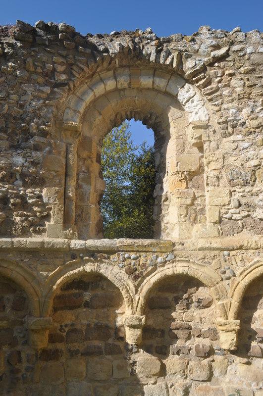
English: Dunwich Leper Hospital, near to Dunwich, Suffolk, Great Britain.
Dunwich leper hospital is the remains of a 13th century building that cared for people affected by leprosy. It was founded well outside town ditch (Pales dyke) by Richard 1st in 1206, maintained by rent from Walter de Riboff. Most likely the hospital was originally a chapel, you can see this from the design. Its Caen limestone has been beautifully carved in Norman fashion. The last leper was buried in 1536 but the building became a more general hospital until abandonment in 1685. It is now in the churchyard of St James which was built in 1830. |
| Date | |
| Source | From geograph.org.uk; transferred by User:Rubberstamp using geograph_org2commons. |
| Author | Ashley Dace |
| Permission (Reusing this file) |
Creative Commons Attribution Share-alike license 2.0 |
| Attribution (required by the license) | Ashley Dace / Dunwich Leper Hospital / |
| Camera location | | View this and other nearby images on: OpenStreetMap |
|---|
| Object location | | View this and other nearby images on: OpenStreetMap |
|---|
_region:GB-GBN_heading:67.00&language=en)
Licensing

|
This image was taken from the Geograph project collection. See this photograph's page on the Geograph website for the photographer's contact details. The copyright on this image is owned by Ashley Dace and is licensed for reuse under the Creative Commons Attribution-ShareAlike 2.0 license.
|
This file is licensed under the Creative Commons Attribution-Share Alike 2.0 Generic license.
Attribution: Ashley Dace
- You are free:
- to share – to copy, distribute and transmit the work
- to remix – to adapt the work
- Under the following conditions:
- attribution – You must give appropriate credit, provide a link to the license, and indicate if changes were made. You may do so in any reasonable manner, but not in any way that suggests the licensor endorses you or your use.
- share alike – If you remix, transform, or build upon the material, you must distribute your contributions under the same or compatible license as the original.
File history
Click on a date/time to view the file as it appeared at that time.
| Date/Time | Dimensions | User | Comment | |
|---|---|---|---|---|
| current | 11:16, 6 May 2011 | 531 × 800 (143 KB) | File Upload Bot (Magnus Manske) |
File usage
The following page uses this file: