File:East Anglia UK Locator Map.svg

Size of this PNG preview of this SVG file: 494 × 600 pixels. Other resolutions: 198 × 240 pixels | 395 × 480 pixels | 633 × 768 pixels | 843 × 1,024 pixels | 1,108 × 1,345 pixels.
Original file (SVG file, nominally 1,108 × 1,345 pixels, file size: 303 KB)
| This is a file from the Wikimedia Commons. The description on its description page there is shown below.
|
Summary
| Description |
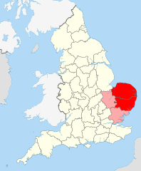
English: Suffolk and Norfolk, the original constituents of East Anglia, are in red. Cambridgeshire – more recently added – in pink.
This image is, inevitably, an approximation and a compromise – it is very hard to properly quantify and emborder East Anglia since it is a completely unofficial region/area. |
||
| Date | |||
| Source |
|
||
| Author | User:Nilfanion User:Wkerry | ||
| SVG development |


Licensing
This file is licensed under the Creative Commons Attribution-Share Alike 3.0 Unported license.
- You are free:
- to share – to copy, distribute and transmit the work
- to remix – to adapt the work
- Under the following conditions:
- attribution – You must give appropriate credit, provide a link to the license, and indicate if changes were made. You may do so in any reasonable manner, but not in any way that suggests the licensor endorses you or your use.
- share alike – If you remix, transform, or build upon the material, you must distribute your contributions under the same or compatible license as the original.
File history
Click on a date/time to view the file as it appeared at that time.
| Date/Time | Dimensions | User | Comment | |
|---|---|---|---|---|
| current | 08:42, 25 May 2022 | 1,108 × 1,345 (303 KB) | Judeobasquelanguage | This isn't true, all of us here identify as east anglian, it would be better if you actually asked for the opinions of essexians before denying us our own identity, thanks |
File usage
The following page uses this file: