File:GWR map.jpg

Original file (1,305 × 1,035 pixels, file size: 600 KB, MIME type: image/jpeg)
| This is a file from the Wikimedia Commons. The description on its description page there is shown below.
|
Summary
| Description |
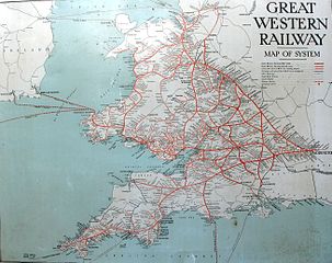
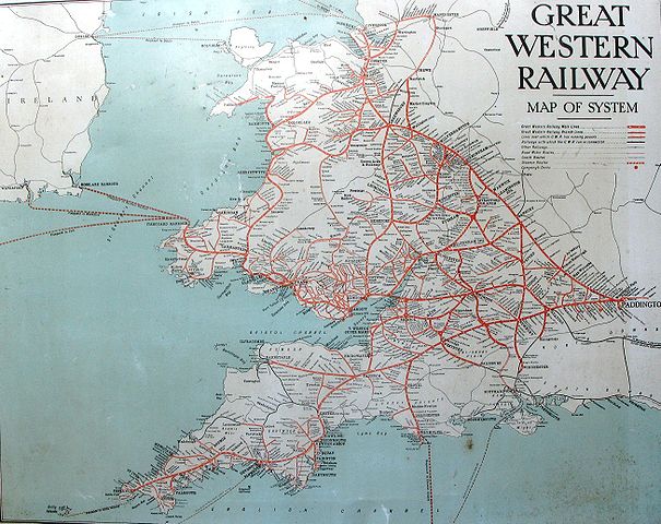
English: A map of the Great Western Railway system in England and Wales. |
| Date | circa 1930 |
| Source | Copy of a Great Western Railway enamel sign |
| Author | Great Western Railway |
| Other versions | Higher resolution cropped images: Cornwall; Devon; Somerset |
Licensing
|
This is a faithful photographic reproduction of a two-dimensional, public domain work of art. The work of art itself is in the public domain for the following reason:
The official position taken by the Wikimedia Foundation is that "faithful reproductions of two-dimensional public domain works of art are public domain". This photographic reproduction is therefore also considered to be in the public domain in the United States. In other jurisdictions, re-use of this content may be restricted; see Reuse of PD-Art photographs for details. {{PD-Art}} template without license parameter: please specify why the underlying work is public domain in both the source country and the United States
(Usage: {{PD-Art|1=|deathyear=''year of author's death''|country=''source country''}}, where parameter 1= can be PD-old-auto, PD-old-auto-expired, PD-old-auto-1996, PD-old-100 or similar. See Commons:Multi-license copyright tags for more information.) | ||||
File history
Click on a date/time to view the file as it appeared at that time.
| Date/Time | Dimensions | User | Comment | |
|---|---|---|---|---|
| current | 00:21, 20 October 2009 | 1,305 × 1,035 (600 KB) | Geof Sheppard | {{Information |Description={{en|1=A map of the Great Western Railway system in England and Wales.}} |Source=Copy of a Great Western Railway enamel sign |Author=Great Western Railway |Date=circa 1930 |Permission= |other_versions= }} |
File usage
The following page uses this file: