File:Greater austria.png

Size of this preview: 703 × 600 pixels. Other resolutions: 281 × 240 pixels | 563 × 480 pixels | 900 × 768 pixels | 1,200 × 1,024 pixels | 1,500 × 1,280 pixels.
Original file (1,500 × 1,280 pixels, file size: 45 KB, MIME type: image/png)
| This is a file from the Wikimedia Commons. The description on its description page there is shown below.
|
Summary
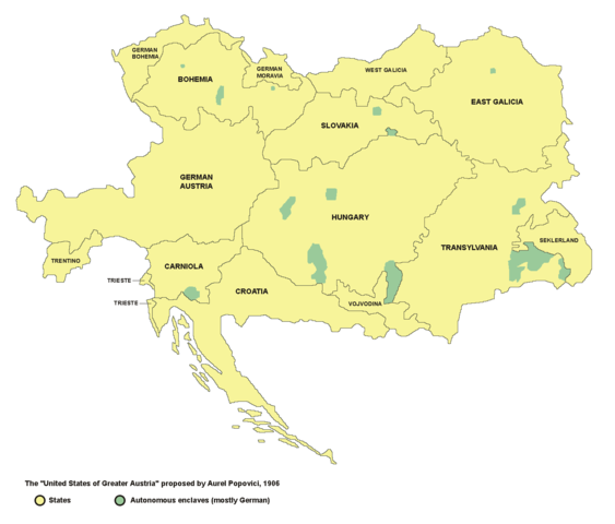
- English: map of the proposed United States of Greater Austria in 1906
- Serbian: мапа предложених Сједињених Држава Велике Аустрије (1906. године)
Source and licence

|
This map has been uploaded by Electionworld from en.wikipedia.org to enable the |
| This work has been released into the public domain by its author, PANONIAN. This applies worldwide. In some countries this may not be legally possible; if so: |
self made map by user:PANONIAN
see de:Bild:Vereinigte Staaten von Groß-Österreich.png for german version. --Rdb 12:12, 2 April 2007 (UTC)
File history
Click on a date/time to view the file as it appeared at that time.
| Date/Time | Dimensions | User | Comment | |
|---|---|---|---|---|
| current | 15:47, 23 December 2006 | 1,500 × 1,280 (45 KB) | Electionworld | {{ew|en|PANONIAN}} {{PD-user|PANONIAN}} map of the {{link|United States of Greater Austria}} (self made) |
File usage
The following page uses this file: