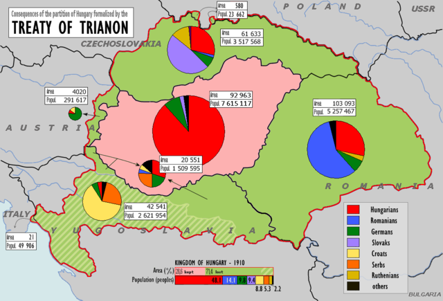
File:Magyarorszag 1920.png

Size of this preview: 800 × 543 pixels. Other resolutions: 320 × 217 pixels | 640 × 435 pixels | 1,024 × 695 pixels | 1,140 × 774 pixels.
Original file (1,140 × 774 pixels, file size: 188 KB, MIME type: image/png)
| This is a file from the Wikimedia Commons. The description on its description page there is shown below.
|

|
This linguistic map image could be re-created using vector graphics as an SVG file. This has several advantages; see Commons:Media for cleanup for more information. If an SVG form of this image is available, please upload it and afterwards replace this template with
{{vector version available|new image name}}.
It is recommended to name the SVG file “Magyarorszag 1920.svg”—then the template Vector version available (or Vva) does not need the new image name parameter. |
Summary
| Description |
Беларуская (тарашкевіца): Трыянонская мірная дамова
English: w:Treaty of Trianon
Magyar: A trianoni békeszerződés következményei
Slovenčina: Následky trianonskej mierovej zmluvy
Čeština: Následky trianonské mírové smlouvy
Deutsch: Friedensvertrag von Trianon
Română: Tratatul de pace de la Trianon
The graphs have been changed for better viewing convenience |
| Date | (UTC) |
| Source | |
| Author |
|
| Other versions | Derivative works of this file: Trianon consequences.png |
| This is a retouched picture, which means that it has been digitally altered from its original version. The original can be viewed here: Hungary1910-1920.png:
|
Licensing
This file is licensed under the Creative Commons Attribution-Share Alike 3.0 Unported license.
- You are free:
- to share – to copy, distribute and transmit the work
- to remix – to adapt the work
- Under the following conditions:
- attribution – You must give appropriate credit, provide a link to the license, and indicate if changes were made. You may do so in any reasonable manner, but not in any way that suggests the licensor endorses you or your use.
- share alike – If you remix, transform, or build upon the material, you must distribute your contributions under the same or compatible license as the original.
Original upload log
This image is a derivative work of the following images:
- File:Hungary1910-1920.png licensed with PD-user-w
- 2008-02-16T16:08:13Z File Upload Bot (Magnus Manske) 1140x776 (139397 Bytes) {{BotMoveToCommons|en.wikipedia}} {{Information |Description={{en|Treaty of Trianon}} |Source=Transferred from [http://en.wikipedia.org en.wikipedia]; Transfer was stated to be made by [[User:Themightyquill]]. (Original text
Uploaded with derivativeFX
File history
Click on a date/time to view the file as it appeared at that time.
| Date/Time | Dimensions | User | Comment | |
|---|---|---|---|---|
| current | 05:45, 17 June 2018 | 1,140 × 774 (188 KB) | Julieta39 | Verified datas according with the original map [https://commons.wikimedia.org/wiki/File:Hungary1910-1920.png] distinguing areas and populations in each territory. Reverted my own mistakes. |
File usage
The following page uses this file: