File:Map of Gaya - en.png
No higher resolution available.
Map_of_Gaya_-_en.png (440 × 342 pixels, file size: 166 KB, MIME type: image/png)
| This is a file from the Wikimedia Commons. The description on its description page there is shown below.
|
Summary
| Description |
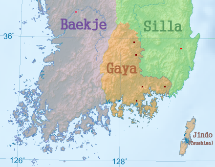
English: Map of Gaya (Version English)
한국어: 가야 지도 (영어판) |
| Date | |
| Source |
Use in: |
| Author | Garam |
| Other versions |
|
Licensing
This file is licensed under the Creative Commons Attribution-Share Alike 3.0 Unported license.
- You are free:
- to share – to copy, distribute and transmit the work
- to remix – to adapt the work
- Under the following conditions:
- attribution – You must give appropriate credit, provide a link to the license, and indicate if changes were made. You may do so in any reasonable manner, but not in any way that suggests the licensor endorses you or your use.
- share alike – If you remix, transform, or build upon the material, you must distribute your contributions under the same or compatible license as the original.
File history
Click on a date/time to view the file as it appeared at that time.
| Date/Time | Dimensions | User | Comment | |
|---|---|---|---|---|
| current | 00:55, 7 January 2012 | 440 × 342 (166 KB) | Garam | {{Information |Description ={{en|1=Map of Gaya (Version English)}} {{ko|1=가야 지도 (영어판)}} |Source =Use in: * File:Korean Peninsula topographic map.png |Author =Idh0854 |Date |
File usage
The following page uses this file: