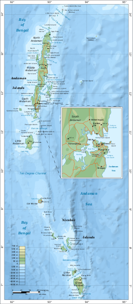
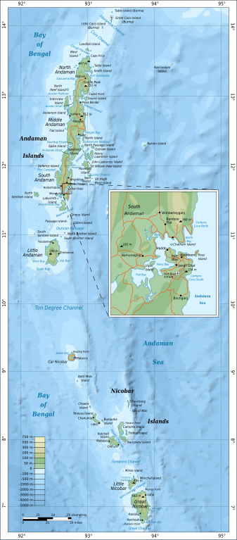
File:Map of Nicobar and Andaman Islands-en.svg

Size of this PNG preview of this SVG file: 263 × 598 pixels. Other resolutions: 105 × 240 pixels | 211 × 480 pixels | 264 × 600 pixels | 337 × 768 pixels | 450 × 1,024 pixels | 906 × 2,060 pixels.
Original file (SVG file, nominally 906 × 2,060 pixels, file size: 621 KB)
| This is a file from the Wikimedia Commons. The description on its description page there is shown below.
|
Summary
| Description | |
| Date | |
| Source | Own work. Self-made in Inkscape. Based on the 1976 CIA Indian Ocean Atlas (Andaman nicobar 76.jpg); bathymetry and topography from SRTM30_PLUS. |
| Author | Oona Räisänen (Mysid) |
| Other versions |
Derivative works of this file: |
| SVG development |
Licensing
I, the copyright holder of this work, hereby publish it under the following licenses:
This file is licensed under the Creative Commons Attribution-Share Alike 3.0 Unported license.
- You are free:
- to share – to copy, distribute and transmit the work
- to remix – to adapt the work
- Under the following conditions:
- attribution – You must give appropriate credit, provide a link to the license, and indicate if changes were made. You may do so in any reasonable manner, but not in any way that suggests the licensor endorses you or your use.
- share alike – If you remix, transform, or build upon the material, you must distribute your contributions under the same or compatible license as the original.

|
Permission is granted to copy, distribute and/or modify this document under the terms of the GNU Free Documentation License, Version 1.2 or any later version published by the Free Software Foundation; with no Invariant Sections, no Front-Cover Texts, and no Back-Cover Texts. A copy of the license is included in the section entitled GNU Free Documentation License. |
You may select the license of your choice.
File history
Click on a date/time to view the file as it appeared at that time.
| Date/Time | Dimensions | User | Comment | |
|---|---|---|---|---|
| current | 09:24, 15 September 2010 | 906 × 2,060 (621 KB) | Mysid | {{Information |Description={{en|1=Map of the Nicobar and Andaman Islands.}} |Source={{own}}. Self-made in Inkscape. Based on the 1976 CIA Indian Ocean Atlas (File:Andaman nicobar 76.jpg); bathymetry and topography from SRTM30_PLUS. |Author=[[w:User:M |
File usage
The following page uses this file: