File:Map of the Holy Roman Empire, 1789 en.png
Size of this preview: 736 × 600 pixels. Other resolutions: 295 × 240 pixels | 589 × 480 pixels | 942 × 768 pixels | 1,256 × 1,024 pixels | 2,650 × 2,160 pixels.
Original file (2,650 × 2,160 pixels, file size: 726 KB, MIME type: image/png)
| This is a file from the Wikimedia Commons. The description on its description page there is shown below.
|
Summary
| Description |
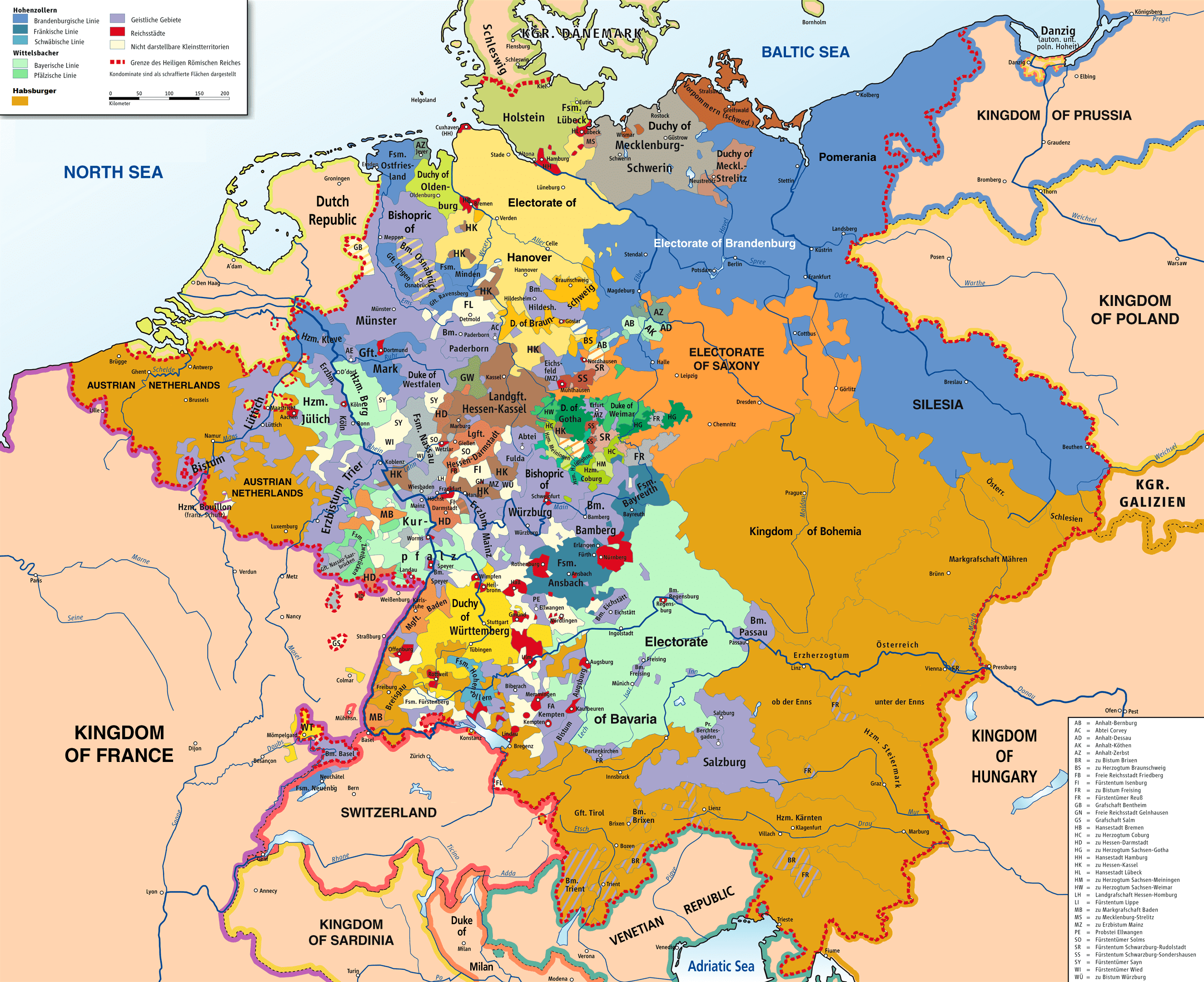
English: Map of the Holy Roman Empire, 1789. |
||
| Date | |||
| Source |
Own work based on: HRR 1789.png "translated (somewhat) from original German version" References:
|
||
| Creator |
Robert Alfers, ziegelbrenner |
||
| Georeferencing | If inappropriate please set warp_status = skip to hide. | ||
| Other versions |
 Ursprungskarte in Deutsch
|

Licensing
This file is licensed under the Creative Commons Attribution-Share Alike 3.0 Unported, 2.5 Generic, 2.0 Generic and 1.0 Generic license.
- You are free:
- to share – to copy, distribute and transmit the work
- to remix – to adapt the work
- Under the following conditions:
- attribution – You must give appropriate credit, provide a link to the license, and indicate if changes were made. You may do so in any reasonable manner, but not in any way that suggests the licensor endorses you or your use.
- share alike – If you remix, transform, or build upon the material, you must distribute your contributions under the same or compatible license as the original.
File history
Click on a date/time to view the file as it appeared at that time.
| Date/Time | Dimensions | User | Comment | |
|---|---|---|---|---|
| current | 07:47, 30 November 2018 | 2,650 × 2,160 (726 KB) | FDRMRZUSA | Implemented map legend: inserted "Kilometers". |
File usage
The following page uses this file: