File:Map of the Territory of the Brigantes.svg

Size of this PNG preview of this SVG file: 424 × 600 pixels. Other resolutions: 170 × 240 pixels | 339 × 480 pixels | 543 × 768 pixels | 724 × 1,024 pixels | 744 × 1,052 pixels.
Original file (SVG file, nominally 744 × 1,052 pixels, file size: 149 KB)
| This is a file from the Wikimedia Commons. The description on its description page there is shown below.
|
| Description |
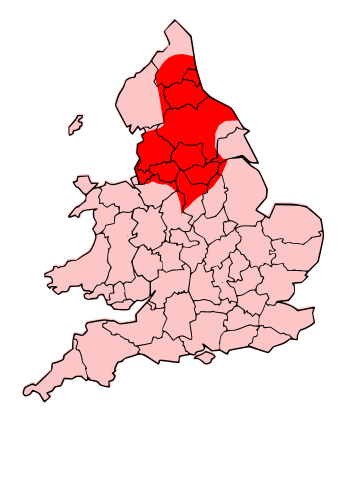
English: County map of England & Wales, overlaid with Territory of the Romano-British Brigantes Tribe of Northern England. |
| Date | (UTC) |
| Source | |
| Author |
|
| Permission (Reusing this file) |
I, the copyright holder of this work, hereby publish it under the following license: This file is licensed under the Creative Commons Attribution-Share Alike 3.0 Unported license.
|
| Other versions | Derivative works of this file: Map of the Territory of the Carvetii.svg |
| This is a retouched picture, which means that it has been digitally altered from its original version. Modifications: Revised to show territory of the Brigantes. The original can be viewed here: England Celtic tribes - North and Midlands.png:
|
Original upload log
This image is a derivative work of the following images:
- File:England_Celtic_tribes_-_North_and_Midlands.png licensed with Cc-by-sa-3.0
- 2009-07-29T23:43:34Z Thomas Gun 296x495 (27459 Bytes) == Summary == {{Information |Description=Image depicting the Celts of North and Midland England, pre-[[Roman Britain]] times. I created this myself, under the guidance (to find location of them) of [http://www.roman-britain.o
Uploaded with derivativeFX
File history
Click on a date/time to view the file as it appeared at that time.
| Date/Time | Dimensions | User | Comment | |
|---|---|---|---|---|
| current | 13:25, 16 October 2009 | 744 × 1,052 (149 KB) | Jpb1301 | {{Information |Description=County map of England & Wales, overlaid with Territory of the Romano-British Brigantes Tribe of Northern England. |Source=*File:England_Celtic_tribes_-_North_and_Midlands.png |Date=2009-10-16 20:19 (UTC) |Author=*[[:File:E |
File usage
The following page uses this file: