File:Mapa ilustrado del Reino de España y sus posesiones para la Guardia Civil.jpg

Size of this preview: 776 × 600 pixels. Other resolutions: 311 × 240 pixels | 621 × 480 pixels | 994 × 768 pixels | 1,280 × 989 pixels | 8,173 × 6,316 pixels.
Original file (8,173 × 6,316 pixels, file size: 38.66 MB, MIME type: image/jpeg)
| This is a file from the Wikimedia Commons. The description on its description page there is shown below.
|
Summary
| Description |
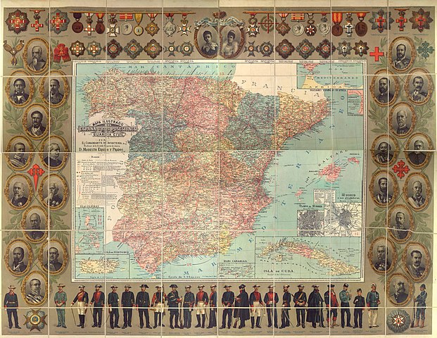
English: Illustrated map of the Kingdom of Spain and its remaining colonial posessions (Spanish Guinea, Spanish Sahara and Spanish Morocco not included) in 1895, prior to the Spanish-American War. This map was produced for the Guardia Civil (Gendarmerie of Spain) and so includes the portraits of the directors of the Guardia Civil. It also includes the different decorations available at the time.
Español: Mapa ilustrado del Reino de España y sus posesiones coloniales (Guinea, Sáhara y Marruecos no incluidas) en 1895, antes de la Guerra hispano-estadounidense. Este mapa fue producido para la Guardia Civil y por lo tanto incluye los retratos de los directores de la Guardia Civil. También incluye las diferentes condecoraciones existentes en dicha época. |
| Date | |
| Source | [1] |
| Author | Eraso y Prados, Modesto |
Licensing
| This file is made available under the Creative Commons CC0 1.0 Universal Public Domain Dedication. | |
| The person who associated a work with this deed has dedicated the work to the public domain by waiving all of their rights to the work worldwide under copyright law, including all related and neighboring rights, to the extent allowed by law. You can copy, modify, distribute and perform the work, even for commercial purposes, all without asking permission.
|
File history
Click on a date/time to view the file as it appeared at that time.
| Date/Time | Dimensions | User | Comment | |
|---|---|---|---|---|
| current | 04:29, 25 April 2018 | 8,173 × 6,316 (38.66 MB) | Helomer | User created page with UploadWizard |
File usage
The following page uses this file: