File:Megalithic grave Harhoog in Keitum, Sylt, Germany.jpg

Size of this preview: 800 × 471 pixels. Other resolutions: 320 × 188 pixels | 640 × 377 pixels | 1,024 × 603 pixels | 1,280 × 753 pixels | 2,664 × 1,568 pixels.
Original file (2,664 × 1,568 pixels, file size: 3.77 MB, MIME type: image/jpeg)
| This is a file from the Wikimedia Commons. The description on its description page there is shown below.
|
Summary
| Description |
Dansk: Harhoog er en cirka 4500 år gammel dysse vest for landsbyen Kejtum på den nordfrisiske ø Sild. Dysen er placeret ved siden af vadet og består af et kravkammer og et stenkreds. Dysen blev udgravet i 1925, men blev flyttet fra sin originale placering i 1954 på grund af lufthavnens opførelse.
Deutsch: Das Megalithgrab Harhoog in Keitum auf Sylt stammt aus der Kupfersteinzeit und wurde um 3.000 v. Chr. gebaut. Es befand sich ursprünglich in der "Weenk" genannten Anhöhe östlich des Wäldchens zwischen Keitum und Tinnum. Es wurde erstmals bei der Ausbeutung einer großen Sandgrube für den Bau des Hindenburgdammes 1925 freigelegt und nach weiteren Sandentnahmen für den Bau des Nössekoogdeiches 1936 wissenschaftlich untersucht. Die Steinkammer des Riesenbettes musste im Juni 1954 verlegt werden, weil das Gelände für die Erweiterung des Sylter Flughafens abgetragen wurde.
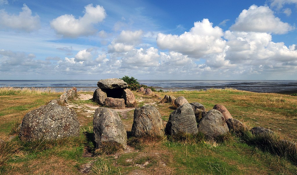
English: Megalithic grave Harhoog located in Keitum on the island of Sylt in Schleswig-Holstein, Germany. The Harhoog is an extended dolmen, a type of megalithic tomb. It was built by the Funnelbeaker culture, probably around 3000 BC. It has been moved from its original location 1954.
Français : Le Harhoog, une tombe mégalithique située à Keitum sur l'île de Sylt au Schleswig-Holstein, en Allemagne. Il s'agit d'un dolmen étendu, construit par les hommes de la culture des vases à entonnoir, probablement vers -3000. Il a été déplacé en 1954 suite à l'agrandissement de l'aéroport de Sylt.
Italiano: Tomba megalitica harhoog (un tipo di dolmen esteso) situata sull'isola a Keitum sull'isola di Sylt Schleswig-Holstein, Germania. Risale probabilmente a circa il 3000 a.C. Nel 1954 è stato spostato dalla sua posizione originale.
Nederlands: De megalithische dolmen Harhoog te Keitum op het eiland Sylt in de Duitse deelstaat Sleeswijk-Holstein.
中文(简体):德国叙尔特岛史前巨石墓穴。 |
| Date | |
| Source | Own work |
| Author | Michael Gäbler |
| Other versions | Derivative works of this file: Sylt banner.jpg |
| Camera location | | View this and other nearby images on: OpenStreetMap |
|---|
|
This image was selected as picture of the day on Wikimedia Commons for 31 December 2012. It was captioned as follows: English: Megalithic grave Harhoog located in Keitum on the island of Sylt in Schleswig-Holstein, Germany. The Harhoog is an extended dolmen, a type of megalithic tomb. It was built by the Funnelbeaker culture, probably around 3000 BC. It has been moved from its original location 1954. Other languages:
Dansk: Harhoog er en cirka 4500 år gammel dysse vest for landsbyen Kejtum på den nordfrisiske ø Sild. Dyssen er placeret ved siden af vadet og består af et kravkammer og et stenkreds. Den blev udgravet i 1925, men blev flyttet fra sin originale placering i 1954 på grund af lufthavnens opførelse. Deutsch: Das Megalithgrab Harhoog in Keitum auf Sylt stammt aus der Kupfersteinzeit und wurde um 3.000 v. Chr. gebaut. Es befand sich ursprünglich in der "Weenk" genannten Anhöhe östlich des Wäldchens zwischen Keitum und Tinnum. Es wurde erstmalig bei der Ausbeutung einer großen Sandgrube für den Bau des Hindenburgdammes 1925 freigelegt und nach weiteren Sandentnahmen für den Bau des Nössekoogdeiches 1936 wissenschaftlich untersucht. Die Steinkammer des Riesenbettes musste im Juni 1954 verlegt werden, weil das Gelände für die Erweiterung des Sylter Flughafens abgetragen wurde. English: Megalithic grave Harhoog located in Keitum on the island of Sylt in Schleswig-Holstein, Germany. The Harhoog is an extended dolmen, a type of megalithic tomb. It was built by the Funnelbeaker culture, probably around 3000 BC. It has been moved from its original location 1954. Français : Le Harhoog, une tombe mégalithique située à Keitum sur l'île de Sylt au Schleswig-Holstein, en Allemagne. Il s'agit d'un dolmen étendu, construit par les hommes de la culture des vases à entonnoir, probablement vers -3000. Il a été déplacé en 1954 suite à l'agrandissement de l'aéroport de Sylt. Italiano: Tomba megalitica harhoog (un tipo di dolmen esteso) situata sull'isola a Keitum sull'isola di Sylt Schleswig-Holstein, Germania. Risale probabilmente a circa il 3000 a.C. Nel 1954 è stato spostato dalla sua posizione originale. Nederlands: De megalithische dolmen Harhoog te Keitum op het eiland Sylt in de Duitse deelstaat Sleeswijk-Holstein. Русский: Дольмен Хартоог, остров Зюльт, Шлезвиг-Гольштейн, Германия 中文: 德国叙尔特岛史前巨石墓穴。 |
Licensing
Michael Gäbler, the copyright holder of this work, hereby publishes it under the following license:
This file is licensed under the Creative Commons Attribution 3.0 Unported license.
Attribution: Michael Gäbler
- You are free:
- to share – to copy, distribute and transmit the work
- to remix – to adapt the work
- Under the following conditions:
- attribution – You must give appropriate credit, provide a link to the license, and indicate if changes were made. You may do so in any reasonable manner, but not in any way that suggests the licensor endorses you or your use.
File history
Click on a date/time to view the file as it appeared at that time.
| Date/Time | Dimensions | User | Comment | |
|---|---|---|---|---|
| current | 07:30, 17 September 2012 | 2,664 × 1,568 (3.77 MB) | Michael Gäbler | Update |
File usage
The following page uses this file: