File:MohaveCountyWaterDepth2006.PNG

Size of this preview: 614 × 600 pixels. Other resolutions: 246 × 240 pixels | 492 × 480 pixels | 786 × 768 pixels | 1,024 × 1,000 pixels.
Original file (1,024 × 1,000 pixels, file size: 735 KB, MIME type: image/png)
| This is a file from the Wikimedia Commons. The description on its description page there is shown below.
|
Summary
| Description |
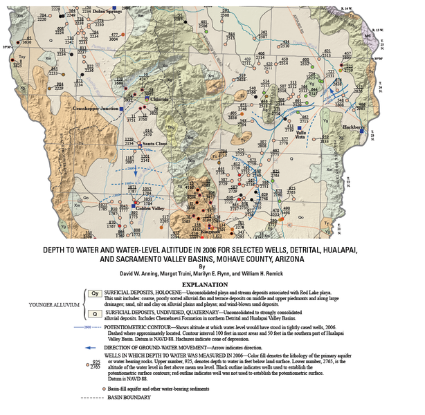
English: 2006 w:United States Geological Survey survey of the depth to water and water-level altitude in w:Arizona for selected wells. |
| Date | |
| Source |
{{cite map|last=Anning|first=
David W.|publisher=[[:w:United States Geological Survey]]|title=Depth to water and water-level altitude in 2006 for selected wells, Detrital, Hualapai, and Sacramento Valley Basins, Mohave County, Arizona—Plate 1|url=http://pubs.usgs.gov/sir/2007/5182/plate/sir2007-5182_plate.pdf|edition=|year=2007|cartography=|scale=1:100,000|series=|page=|section=|inset=|accessdate=2008-12-22|isbn=|id=}} |
| Author | David W. Anning as modified by -- Suntag ☼ |
Licensing
This image is in the public domain in the United States because it only contains materials that originally came from the United States Geological Survey, an agency of the United States Department of the Interior. For more information, see the official USGS copyright policy.
|
File history
Click on a date/time to view the file as it appeared at that time.
| Date/Time | Dimensions | User | Comment | |
|---|---|---|---|---|
| current | 12:21, 22 December 2008 | 1,024 × 1,000 (735 KB) | Suntag | Upload |
File usage
The following page uses this file: