File:Nazi-parading-in-elysian-fields-paris-desert-1940.png
No higher resolution available.
Nazi-parading-in-elysian-fields-paris-desert-1940.png (720 × 480 pixels, file size: 230 KB, MIME type: image/png)
| This is a file from the Wikimedia Commons. The description on its description page there is shown below.
|
Summary
| Description |
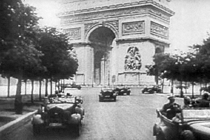
English: German Nazi officers parading in the deserted Foch avenue, Paris, France (1940).
Screenshot taken from the 1943 United States Army propaganda film Divide and Conquer (Why We Fight #3) directed by Frank Capra and partially based on, news archives, animations, restaged scenes and captured propaganda material from both sides.
Français : Officiers allemands paradant sur l'avenue Foch déserte, Paris, France (1940).
Photographie tirée du film de propagande de l'Armée américaine de 1943 Divide and Conquer (Why We Fight #3) – en français : Diviser et Conquérir (Pourquoi nous nous battons (vol.3) ?) – réalisé par Frank Capra et basé en partie sur des archives d'actualités de l'époque, des animations, des reconstitutions et du matériel de propagande récupéré des deux bords.
Deutsch: Deutsche Nazi-Offiziere in der verlassenen Avenue Foch, Paris, Frankreich (1940).
Bildschirmfoto des 1943 entstandenen US-Armee-Propagandafilms Divide and Conquer/Teile und Beherrsche (Why We Fight #3/Warum wir kämpfen, Kapitel 3), Regie Frank Capra. Der Film verwendet teilweise Nachrichtenarchive, Animationen, nachgestellte Szenen und Propagandamaterial beider Seiten. |
| Date | (event), 1943 (film) |
| Source | Divide and Conquer (Why We Fight #3) Public Domain (U.S. War Department): https://archive.org/details/DivideAndConquer |
| Author | Frank Capra (director), U.S. War Department |
| Camera location | | View this and other nearby images on: OpenStreetMap |
|---|
Licensing
This image is a work of a U.S. military or Department of Defense employee, taken or made as part of that person's official duties. As a work of the U.S. federal government, the image is in the public domain in the United States.
|
 |
File history
Click on a date/time to view the file as it appeared at that time.
| Date/Time | Dimensions | User | Comment | |
|---|---|---|---|---|
| current | 06:13, 7 March 2010 | 720 × 480 (230 KB) | Hohum | Levels, cleaned slightly. |
File usage
The following page uses this file: