File:Pacific elevation.jpg

Size of this preview: 632 × 599 pixels. Other resolutions: 253 × 240 pixels | 506 × 480 pixels | 633 × 600 pixels | 810 × 768 pixels | 1,080 × 1,024 pixels | 2,500 × 2,370 pixels.
Original file (2,500 × 2,370 pixels, file size: 899 KB, MIME type: image/jpeg)
| This is a file from the Wikimedia Commons. The description on its description page there is shown below.
|
Summary
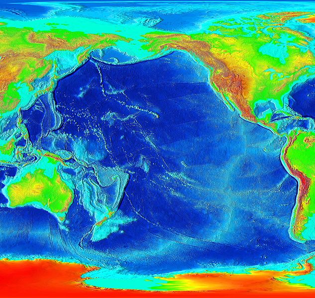
Elevation of the Pacific ocean
Source: ETOPO2v2, a digital database of seafloor and land elevations created by the World Data Center for Geophysics & Marine Geology (Boulder, CO), National Geophysical Data Center, NOAA.
Licensing
This image is in the public domain because it contains materials that originally came from the U.S. National Oceanic and Atmospheric Administration, taken or made as part of an employee's official duties.
|
derivative works
Derivative works of this file: Pacific elevation2.jpg
File history
Click on a date/time to view the file as it appeared at that time.
| Date/Time | Dimensions | User | Comment | |
|---|---|---|---|---|
| current | 20:41, 6 March 2006 | 2,500 × 2,370 (899 KB) | Interiot~commonswiki | Elevation of the Pacific ocean Source: http://www.ngdc.noaa.gov/mgg/image/2minrelief.html |
File usage
The following page uses this file: