File:Paloma near peak IR.GIF

Size of this preview: 600 × 600 pixels. Other resolutions: 240 × 240 pixels | 480 × 480 pixels | 900 × 900 pixels.
Original file (900 × 900 pixels, file size: 383 KB, MIME type: image/gif)
| This is a file from the Wikimedia Commons. The description on its description page there is shown below.
|
Summary
| Description |
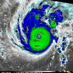
English: Infrared satellite image of Hurricane Paloma taken by 1 km Mercator, MODIS/AVHRR Satellite on November 7, 2008 at 1008 UTC (4:08 EST). At the time this image was taken, Hurricane Paloma had sustained winds of 140mph (120 km/h). |
| Date | |
| Source | NOAA RAMMB MODIS Infrared archive |
| Author | NOAA and NASA |
| Permission (Reusing this file) |
Public Domain |
Licensing
| This file is in the public domain in the United States because it was solely created by NASA. NASA copyright policy states that "NASA material is not protected by copyright unless noted". (See Template:PD-USGov, NASA copyright policy page or JPL Image Use Policy.) | ||
 |
Warnings:
|
File history
Click on a date/time to view the file as it appeared at that time.
| Date/Time | Dimensions | User | Comment | |
|---|---|---|---|---|
| current | 05:16, 1 February 2009 | 900 × 900 (383 KB) | Cyclonebiskit | {{Information |Description={{en|1=Infrared satellite image of Hurricane Paloma taken by 1 km Mercator, MODIS/AVHRR Satellite on November 7, 2008 at 1008 UTC (4:08 EST). At the time this image was taken, Hurricane Paloma had sustained winds of 140mph (120 |
File usage
The following page uses this file: