File:Pink-house-charleston-sc1.jpg

Size of this preview: 410 × 600 pixels. Other resolutions: 164 × 240 pixels | 328 × 480 pixels | 525 × 768 pixels | 700 × 1,024 pixels | 2,095 × 3,064 pixels.
Original file (2,095 × 3,064 pixels, file size: 1.68 MB, MIME type: image/jpeg)
| This is a file from the Wikimedia Commons. The description on its description page there is shown below.
|
|
This is an image of a place or building that is listed on the National Register of Historic Places in the United States of America. Its reference number is 73001682. |
Summary
| Description |
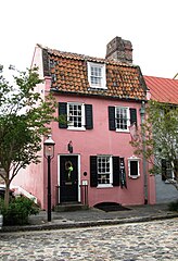
English: The Pink House, built circa 1712, in Charleston, South Carolina, USA. The house is listed on the National Register of Historic Places as a contributing building in the French Quarter District. As was by then typical of the Architecture of Bermuda, the house was built of limestone from Bermuda (Charleston had been settled from Bermuda under William Sayle in the 1670s, and Bermudians retained close links with the city up to American independence). |
| Date | |
| Source | Own work |
| Author | Brian Stansberry |
| Camera location | | View this and other nearby images on: OpenStreetMap |
|---|
| Object location | | View this and other nearby images on: OpenStreetMap |
|---|
Licensing
I, the copyright holder of this work, hereby publish it under the following license:
This file is licensed under the Creative Commons Attribution 3.0 Unported license.
- You are free:
- to share – to copy, distribute and transmit the work
- to remix – to adapt the work
- Under the following conditions:
- attribution – You must give appropriate credit, provide a link to the license, and indicate if changes were made. You may do so in any reasonable manner, but not in any way that suggests the licensor endorses you or your use.
File history
Click on a date/time to view the file as it appeared at that time.
| Date/Time | Dimensions | User | Comment | |
|---|---|---|---|---|
| current | 11:01, 22 August 2017 | 2,095 × 3,064 (1.68 MB) | Migebert | Cropped < 1 % horizontally using CropTool with precise mode. Rotation 90°. |
File usage
The following page uses this file: