File:PlanoMontevideoSitioGrande.JPG
Original file(924 × 657 pixels, file size: 147 KB, MIME type: image/jpeg)

Commons-logo.svg This is a file from the Wikimedia Commons. The description on its description page there is shown below.
Commons is a freely licensed media file repository. You can help.

Summary

Description
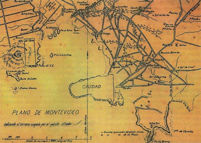
English: Former map of Montevideo (Uruguay) and surrounding towns (now converted into neighborhoods of the city), developed during the called Guerra Grande (Great War, 1843 - 1851), where the demarcation area occupied by the siege army of Montevideo.
Español: Mapa antiguo de Montevideo y pueblos aledaños (Pueblo de la Victoria, actual barrio de La Teja, y el hoy también barrio de Villa del Cerro) donde se indica el territorio ocupado por el ejército sitiador de Montevideo en el transcurso de la Guerra Grande.
Date Entre 1843 y 1851 (Período temporal de duración de la Guerra Grande)
Source Digitalizado del libro Gran Enciclopedia del Uruguay
Author Unknown authorUnknown author
Other versions
Public domain
This file has been placed in the public domain according the Uruguayan law 9.739, law 17.616, and its subsequent amendments (details). At least 70 years have passed since the author's death.

You must also include a United States public domain tag to indicate why this work is in the public domain in the United States. Note that a few countries have copyright terms longer than 70 years: Mexico has 100 years, Jamaica has 95 years, Colombia has 80 years, and Guatemala and Samoa have 75 years. This image may not be in the public domain in these countries, which moreover do not implement the rule of the shorter term. Honduras has a general copyright term of 75 years, but it does implement the rule of the shorter term. Copyright may extend on works created by French who died for France in World War II (more information), Russians who served in the Eastern Front of World War II (known as the Great Patriotic War in Russia) and posthumously rehabilitated victims of Soviet repressions (more information).

English | español | русский | +/−

Licensing

Public domain

This work is in the public domain in its country of origin and other countries and areas where the copyright term is the author's life plus 70 years or fewer.


You must also include a United States public domain tag to indicate why this work is in the public domain in the United States. Note that a few countries have copyright terms longer than 70 years: Mexico has 100 years, Jamaica has 95 years, Colombia has 80 years, and Guatemala and Samoa have 75 years. This image may not be in the public domain in these countries, which moreover do not implement the rule of the shorter term. Honduras has a general copyright term of 75 years, but it does implement the rule of the shorter term. Copyright may extend on works created by French who died for France in World War II (more information), Russians who served in the Eastern Front of World War II (known as the Great Patriotic War in Russia) and posthumously rehabilitated victims of Soviet repressions (more information).

Captions

Add a one-line explanation of what this file represents

Items portrayed in this file

depicts

image/jpeg

File history

Click on a date/time to view the file as it appeared at that time.

Date/TimeDimensionsUserComment
current15:15, 17 July 2008924 × 657 (147 KB)Uruguayo-92{{Information |Description={{en|1=Former map of Montevideo (Uruguay) and surrounding towns (now converted into neighborhoods of the city), developed during the called ''Guerra Grande'' (Great War, 1843 - 1851), where the demarcation area occupied by the s

The following page uses this file: