File:Political divisions of Mexico 1821 (location map scheme).svg

Size of this PNG preview of this SVG file: 631 × 599 pixels. Other resolutions: 253 × 240 pixels | 505 × 480 pixels | 632 × 600 pixels | 808 × 768 pixels | 1,078 × 1,024 pixels | 1,200 × 1,140 pixels.
Original file (SVG file, nominally 1,200 × 1,140 pixels, file size: 413 KB)
| This is a file from the Wikimedia Commons. The description on its description page there is shown below.
|
.svg)
Summary
| Description |
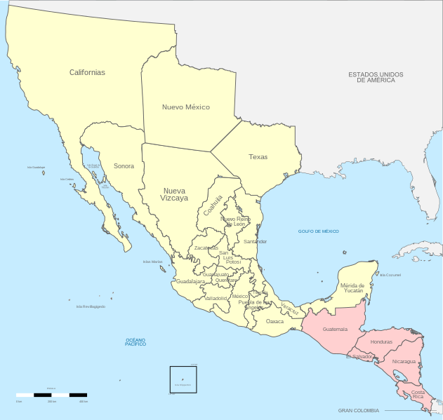
English: Political divisions of 1821 Mexico.
Treaty of Cordoba
Acquisitions (1821–1822) Español: Divisiones políticas de México en 1821.
Page 87 Tratados de Córdoba
Adquisiciones (1821-1822) |
| Date | |
| Source |
Own work Instituto Nacional de Estadística y Geografía (INEGI) |
| Author | Giggette |
| SVG development | |
| Attribution (required by the license) | © Giggette / Wikimedia Commons / |
| Camera location | | View this and other nearby images on: OpenStreetMap |
|---|
.svg¶ms=019.409500_N_-099.130700_E_globe:Earth_type:camera_type:satellite_region:MX_heading:0.00&language=en)
Territorio de mexico, 1821.
Licensing
I, the copyright holder of this work, hereby publish it under the following licenses:
This file is licensed under the Creative Commons Attribution-Share Alike 3.0 Unported license.
- You are free:
- to share – to copy, distribute and transmit the work
- to remix – to adapt the work
- Under the following conditions:
- attribution – You must give appropriate credit, provide a link to the license, and indicate if changes were made. You may do so in any reasonable manner, but not in any way that suggests the licensor endorses you or your use.
- share alike – If you remix, transform, or build upon the material, you must distribute your contributions under the same or compatible license as the original.

|
Permission is granted to copy, distribute and/or modify this document under the terms of the GNU Free Documentation License, Version 1.2 or any later version published by the Free Software Foundation; with no Invariant Sections, no Front-Cover Texts, and no Back-Cover Texts. A copy of the license is included in the section entitled GNU Free Documentation License. |
You may select the license of your choice.
File history
Click on a date/time to view the file as it appeared at that time.
| Date/Time | Dimensions | User | Comment | |
|---|---|---|---|---|
| current | 15:18, 18 April 2023 | 1,200 × 1,140 (413 KB) | Hohum | Cartographic colours |
File usage
The following 3 pages use this file:
.svg)