File:Range map Tapirus bairdii with borders.png
No higher resolution available.
Range_map_Tapirus_bairdii_with_borders.png (338 × 419 pixels, file size: 8 KB, MIME type: image/png)
| This is a file from the Wikimedia Commons. The description on its description page there is shown below.
|
Summary
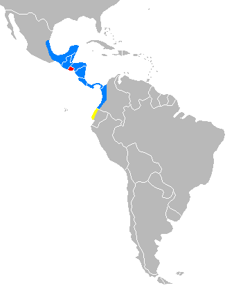
| Description | Distribution of Tapirus bairdii with national borders added |
| Date | |
| Source | Own work |
| Author | tr:Kullanıcı:Mskyrider |
Explications
Created from the information on [1] archive copy at the Wayback Machine. In red El Salvador where Baird's Tapir is extinct. In yellow Ecuador where Baird's Tapir presence is unconfirmed. In blue actual distribution.
Licensing
| I, the copyright holder of this work, release this work into the public domain. This applies worldwide. In some countries this may not be legally possible; if so: I grant anyone the right to use this work for any purpose, without any conditions, unless such conditions are required by law. |
File history
Click on a date/time to view the file as it appeared at that time.
| Date/Time | Dimensions | User | Comment | |
|---|---|---|---|---|
| current | 03:59, 12 July 2019 | 338 × 419 (8 KB) | Prosfilaes | Reverted to version as of 20:51, 24 February 2007 (UTC) |
File usage
The following 2 pages use this file: