File:Ravenna Cosmography 1889 Africa crop.jpg

Original file (1,744 × 960 pixels, file size: 385 KB, MIME type: image/jpeg)
| This is a file from the Wikimedia Commons. The description on its description page there is shown below.
|
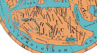
| Description | Weltkarte des anonymen Ravennaten Reconstruction of the Ravenna Cosmography c. 600 AD using Ravenna place name list and a Ptolemic map form. |
| Date | (UTC) |
| Source | |
| Author |
|
| This is a retouched picture, which means that it has been digitally altered from its original version. Modifications: crop showing Africa, lightened, regularised colours. The original can be viewed here: Karte Ravennat.jpg:
|
|
This work is in the public domain in its country of origin and other countries and areas where the copyright term is the author's life plus 70 years or fewer.
| |
| This file has been identified as being free of known restrictions under copyright law, including all related and neighboring rights. | |
Original upload log
This image is a derivative work of the following images:
- Image:Karte_Ravennat.jpg licensed with PD-old
- 2008-05-13T19:55:51Z Fingalo 2448x3264 (4092551 Bytes) == Beschreibung == {{Information |Description=Weltkarte des anonymen Ravennaten |Source=Mappae Mundi Bd. Vi. "Rekonstruierte Karten" |Date=1898 |Author=Dr. Konrad Miller |Permission= |other_versions= }} [[Category:Fingalo]] [
Uploaded with derivativeFX
File history
Click on a date/time to view the file as it appeared at that time.
| Date/Time | Dimensions | User | Comment | |
|---|---|---|---|---|
| current | 12:19, 12 August 2008 | 1,744 × 960 (385 KB) | T L Miles | {{Information |Description=Weltkarte des anonymen Ravennaten Reconstruction of the Ravenna Cosmography c. 600 AD using Ravenna place name list and a Ptolemic map form. |Source=*Image:Karte_Ravennat.jpg |Date=2008-08-12 19:18 (UTC) |Author=*deri |
File usage
The following page uses this file: