File:Richland-Plummer Creek Covered Bridge, southern side and eastern end.jpg

Size of this preview: 800 × 600 pixels. Other resolutions: 320 × 240 pixels | 640 × 480 pixels | 1,024 × 768 pixels | 1,280 × 960 pixels | 2,816 × 2,112 pixels.
Original file (2,816 × 2,112 pixels, file size: 2.77 MB, MIME type: image/jpeg)
| This is a file from the Wikimedia Commons. The description on its description page there is shown below.
|
|
This is an image of a place or building that is listed on the National Register of Historic Places in the United States of America. Its reference number is 93000466. |
| Camera location | | View this and other nearby images on: OpenStreetMap |
|---|
| Description |
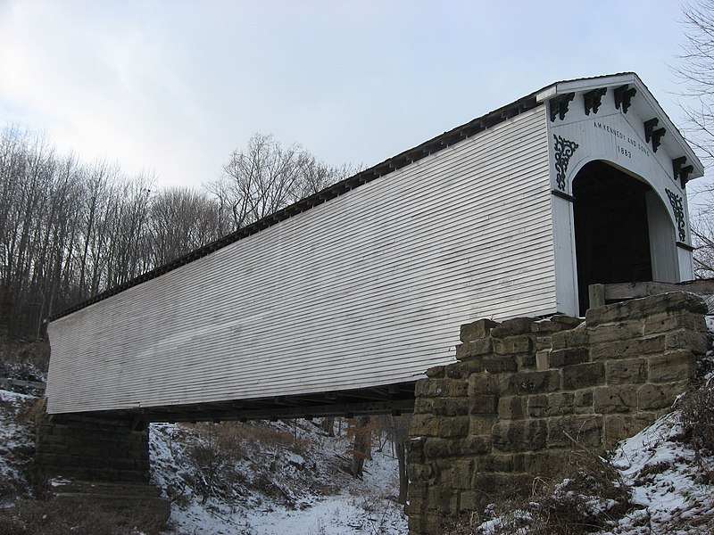
English: Southern side and eastern portal of the Richland-Plummer Creek Covered Bridge, which carries Baseline Road/Road 25E over Plummer Creek south of Bloomfield in Taylor Township, Greene County, Indiana, United States. Built in 1883, it is listed on the National Register of Historic Places. |
||
| Date | Taken on 18 December 2010 | ||
| Source | Own work | ||
| Author | Nyttend | ||
| Permission (Reusing this file) |
|
File history
Click on a date/time to view the file as it appeared at that time.
| Date/Time | Dimensions | User | Comment | |
|---|---|---|---|---|
| current | 06:01, 21 December 2010 | 2,816 × 2,112 (2.77 MB) | Nyttend | {{Location|38|59|34|N|86|56|16|W}} {{Information |Description={{en|Southern side and eastern portal of the {{w|Richland-Plummer Creek Covered Bridge}}, which carries Baseline Road/Road 25E over Plummer Creek south of {{w|Bloomfield, Indiana|Bloomfield}} i |
File usage
The following page uses this file: