File:Russian chapel at Fort Ross (2016).jpg
Original file (5,339 × 3,559 pixels, file size: 15.15 MB, MIME type: image/jpeg)
This is a file from the Wikimedia Commons. The description on its description page there is shown below.
|
Summary
DescriptionRussian chapel at Fort Ross (2016).jpg |
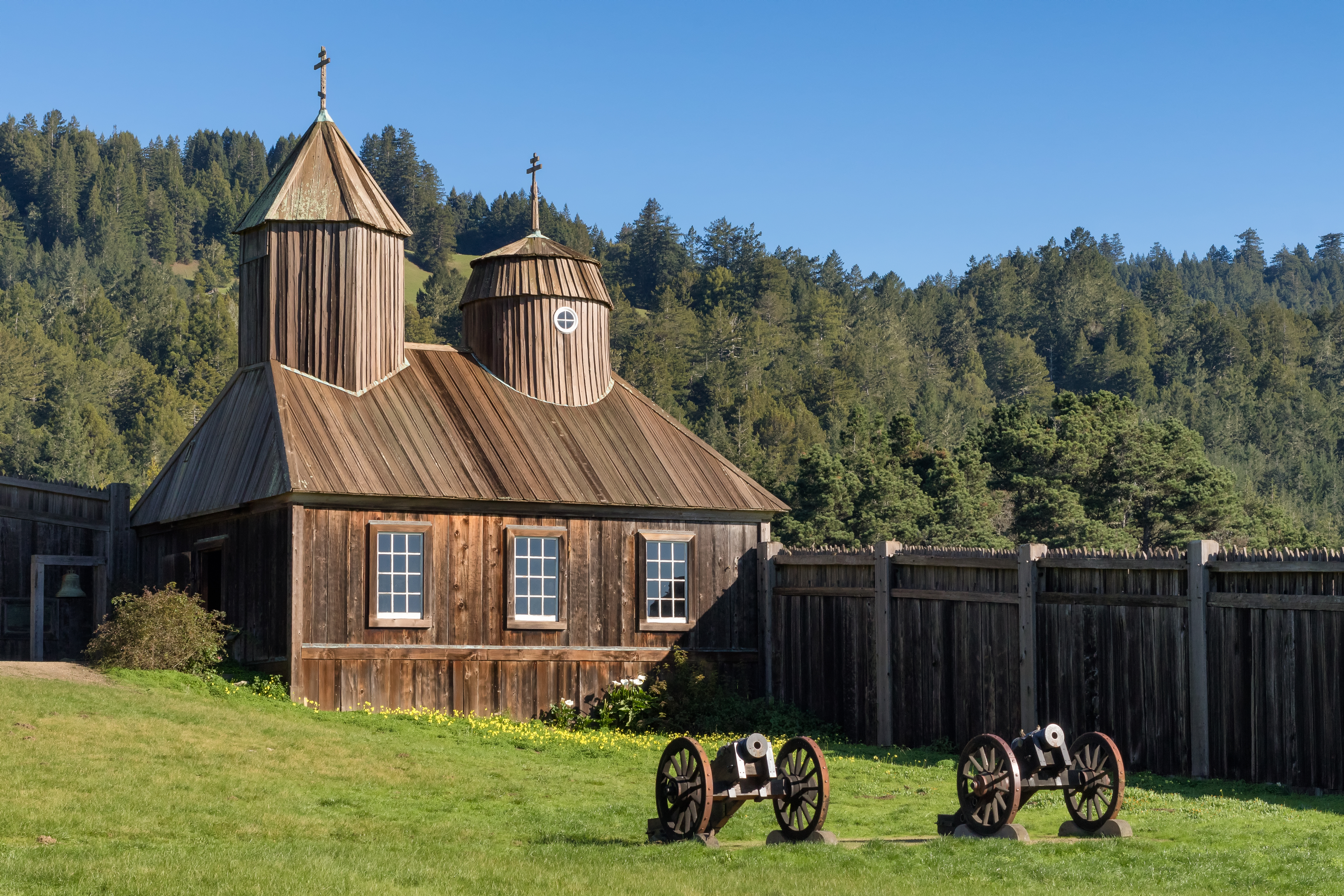
English: Orthodox Holy Trinity St. Nicholas Chapel at Fort Ross, Sonoma County, California. The chapel is part of the Fort Ross State Historic Park. The chapel was originally built in the mid-1820s and got destroyed in the 1906 earthquake. In 1970, a restored version of the chapel was entirely destroyed in an accidental fire. The photo shows the reconstructed chapel, built in 1973. It continues to be used for Orthodox religious services. |
|||||||||||||||||||||||
Date | Taken on 18 December 2016, 11:14:06 | |||||||||||||||||||||||
Source | Own work | |||||||||||||||||||||||
Author |
creator QS:P170,Q57175365 |
|||||||||||||||||||||||
Attribution (required by the license) InfoField | © Frank Schulenburg / | |||||||||||||||||||||||
InfoField | © Frank Schulenburg |
Camera location | 38° 30′ 50.57″ N, 123° 14′ 36.1″ W | View this and other nearby images on: OpenStreetMap | 38.514047; -123.243362 |
---|
|
Licensing
- You are free:
- to share – to copy, distribute and transmit the work
- to remix – to adapt the work
- Under the following conditions:
- attribution – You must give appropriate credit, provide a link to the license, and indicate if changes were made. You may do so in any reasonable manner, but not in any way that suggests the licensor endorses you or your use.
- share alike – If you remix, transform, or build upon the material, you must distribute your contributions under the same or compatible license as the original.
This image has been assessed using the Quality image guidelines and is considered a Quality image.
العربية ∙ جازايرية ∙ беларуская ∙ беларуская (тарашкевіца) ∙ български ∙ বাংলা ∙ català ∙ čeština ∙ Cymraeg ∙ Deutsch ∙ Schweizer Hochdeutsch ∙ Zazaki ∙ Ελληνικά ∙ English ∙ Esperanto ∙ español ∙ eesti ∙ euskara ∙ فارسی ∙ suomi ∙ français ∙ galego ∙ עברית ∙ हिन्दी ∙ hrvatski ∙ magyar ∙ հայերեն ∙ Bahasa Indonesia ∙ italiano ∙ 日本語 ∙ Jawa ∙ ქართული ∙ 한국어 ∙ kurdî ∙ Lëtzebuergesch ∙ lietuvių ∙ македонски ∙ മലയാളം ∙ मराठी ∙ Bahasa Melayu ∙ Nederlands ∙ Norfuk / Pitkern ∙ polski ∙ português ∙ português do Brasil ∙ rumantsch ∙ română ∙ русский ∙ sicilianu ∙ slovenčina ∙ slovenščina ∙ shqip ∙ српски / srpski ∙ svenska ∙ தமிழ் ∙ తెలుగు ∙ ไทย ∙ Tagalog ∙ Türkçe ∙ toki pona ∙ українська ∙ vèneto ∙ Tiếng Việt ∙ 中文 ∙ 中文(简体) ∙ 中文(繁體) ∙ +/− |
18 December 2016
38°30'50.569"N, 123°14'36.103"W
0.001 second
50 millimetre
400
image/jpeg
File history
Click on a date/time to view the file as it appeared at that time.
Date/Time | Dimensions | User | Comment | |
---|---|---|---|---|
current | 13:14, 14 January 2017 | 5,339 × 3,559 (15.15 MB) | Frank Schulenburg | Selective noise reduction applied to sky |
File usage
The following 2 pages use this file:
Metadata
This file contains additional information, probably added from the digital camera or scanner used to create or digitize it.
If the file has been modified from its original state, some details may not fully reflect the modified file.
Camera manufacturer | Canon |
---|---|
Camera model | Canon EOS 7D Mark II |
Author | Frank Schulenburg |
Copyright holder |
|
Exposure time | 1/1,000 sec (0.001) |
F Number | f/8 |
ISO speed rating | 400 |
Date and time of data generation | 11:14, 18 December 2016 |
Lens focal length | 50 mm |
Latitude | 38° 30′ 50.57″ N |
Longitude | 123° 14′ 36.1″ W |
Altitude | 33.1 meters above sea level |
Width | 5,339 px |
Height | 3,559 px |
Bits per component |
|
Pixel composition | RGB |
Orientation | Normal |
Number of components | 3 |
Horizontal resolution | 240 dpi |
Vertical resolution | 240 dpi |
Software used | Adobe Photoshop CC 2017 (Macintosh) |
File change date and time | 12:12, 14 January 2017 |
Exposure Program | Aperture priority |
Exif version | 2.3 |
Date and time of digitizing | 11:14, 18 December 2016 |
APEX shutter speed | 9.965784 |
APEX aperture | 6 |
APEX exposure bias | -0.66666666666667 |
Maximum land aperture | 1 APEX (f/1.41) |
Metering mode | Pattern |
Flash | Flash did not fire, compulsory flash suppression |
DateTimeOriginal subseconds | 57 |
Color space | sRGB |
Focal plane X resolution | 2,439.5010141988 |
Focal plane Y resolution | 2,439.5010141988 |
Focal plane resolution unit | 3 |
Exposure mode | Auto exposure |
White balance | Auto white balance |
Scene capture type | Standard |
GPS time (atomic clock) | 19:16 |
Satellites used for measurement | 22 |
Receiver status | Measurement in progress |
Measurement mode | 3-dimensional measurement |
Measurement precision | Moderate (1.8) |
Reference for direction of image | Magnetic direction |
Geodetic survey data used | WGS-84 |
GPS date | 18 December 2016 |
GPS tag version | 0.0.3.2 |
Serial number of camera | 058021011142 |
Lens used | Zeiss Milvus 1.4/50 ZE |
Date metadata was last modified | 04:12, 14 January 2017 |
Unique ID of original document | 26183E03B384E71A1E5C73385B178256 |
Keywords |
|
Contact information | frank@wikiphotographer.net
150 Seminary Drive 2A Mill Valley, California, 94941 United States |
City shown | Jenner |
Province or state shown | California |
Country shown | USA |
Code for country shown | US |
IIM version | 4 |