File:Tamis banat1751 1778.png
Size of this preview: 621 × 600 pixels. Other resolutions: 248 × 240 pixels | 497 × 480 pixels | 996 × 962 pixels.
Original file (996 × 962 pixels, file size: 112 KB, MIME type: image/png)
| This is a file from the Wikimedia Commons. The description on its description page there is shown below.
|
Summary
| Description |
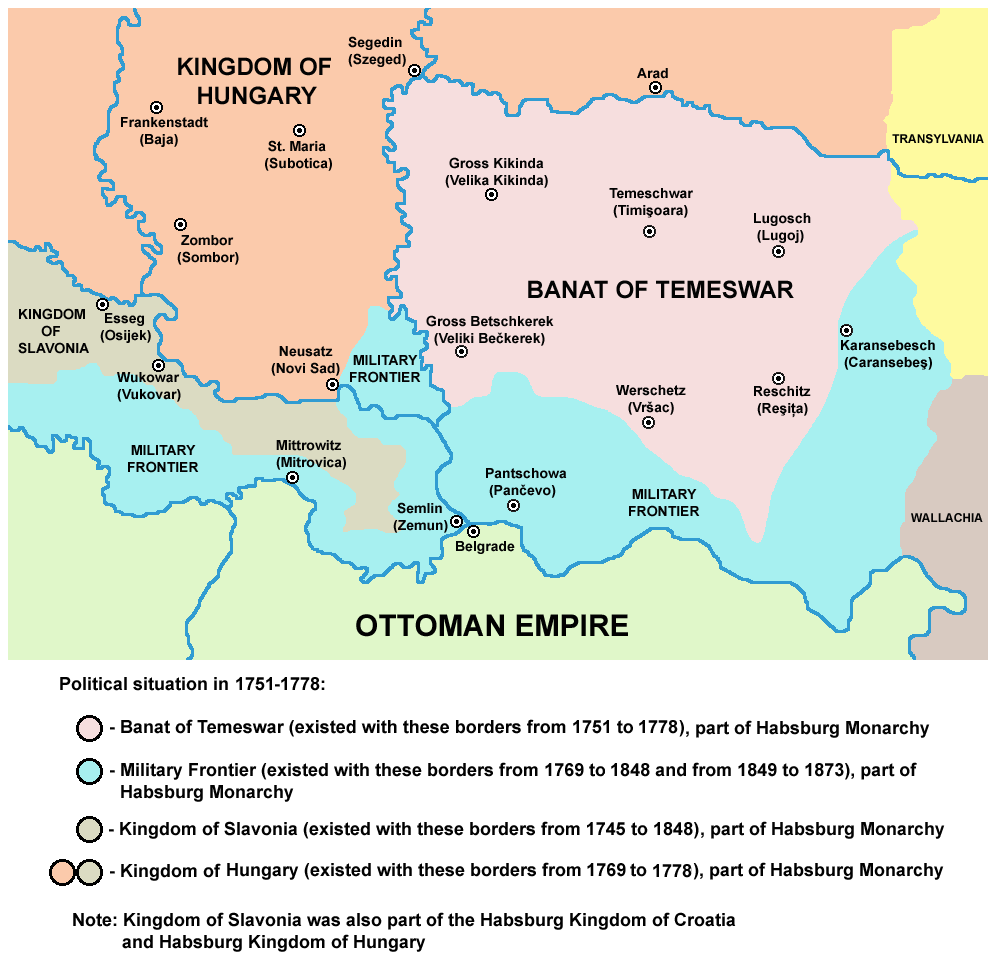
English: map of the Banat of Temeswar, Kingdom of Slavonia and Military Frontier in 1751-1778.
Српски / srpski: мапа Тамишког Баната, Краљевине Славоније и војне границе (1751-1778. године) |
| Date | 1 August 2009 (original upload date) |
| Source | No machine-readable source provided. Own work assumed (based on copyright claims). |
| Author | No machine-readable author provided. PANONIAN assumed (based on copyright claims). |
References
- The Times History of Europe, Times Books, 2002.
- Denis Šehić - Demir Šehić, Istorijski atlas Sveta, Beograd, 2007.
- Milan Tutorov, Banatska rapsodija - istorika Zrenjanina i Banata, Novi Sad, 2001.
- Peter Rokai - Zoltan Đere - Tibor Pal - Aleksandar Kasaš, Istorija Mađara, Beograd, 2002.
- Dr Dušan J. Popović, Srbi u Vojvodini, knjiga 2, Novi Sad, 1990.
- Dr Milenko Palić, Srbi u Mađarskoj - Ugarskoj do 1918, Novi Sad, 1995.
- J. H. Šviker, Politička istorija Srba u Ugarskoj, Novi Sad - Beograd, 1998.
- Fridrih Vilhelm fon Taube, Istorijski i geografski opis Kraljevine Slavonije i Vojvodstva Srema, Novi Sad, 1998.
- Miodrag Milin, Vekovima zajedno (Iz istorije srpsko-rumunskih odnosa), Temišvar, 1995.
- Suzana Milovanović, Potiska i pomoriška vojna granica (1702-1751), Novi Sad, 2003.
- Dimitrije Boarov, Politička istorija Vojvodine, Novi Sad, 2001.
- Drago Njegovan, Prisajedinjenje Vojvodine Srbiji, Novi Sad, 2004.
Licensing
self made map by user:PANONIAN
| I, the copyright holder of this work, release this work into the public domain. This applies worldwide. In some countries this may not be legally possible; if so: I grant anyone the right to use this work for any purpose, without any conditions, unless such conditions are required by law. |
File history
Click on a date/time to view the file as it appeared at that time.
| Date/Time | Dimensions | User | Comment | |
|---|---|---|---|---|
| current | 04:55, 24 June 2014 | 996 × 962 (112 KB) | PANONIAN | aesthetics |
File usage
The following page uses this file: