File:The Shard from the Sky Garden 2015.jpg

Size of this preview: 298 × 598 pixels. Other resolutions: 119 × 240 pixels | 239 × 480 pixels | 299 × 600 pixels | 382 × 768 pixels | 510 × 1,024 pixels | 5,472 × 10,986 pixels.
Original file (5,472 × 10,986 pixels, file size: 16.87 MB, MIME type: image/jpeg)
| This is a file from the Wikimedia Commons. The description on its description page there is shown below.
|
Summary
| Description |
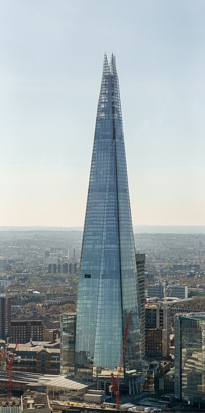
English: The Shard, taken from the Sky Garden atop the "Walkie-Talkie". A window is open, which allows a crane to lower a box that holds the window cleaners. The people walking at the bottom of this tower are approximately 170 × smaller than the building.
Photographer's notes: The image is stitched from 28 landscape-orientation frames in three columns. The viewpoint is the balcony of the "Sky Garden" at the top of the Walkie-Talkie. This is approximately halfway up the 306m Shard and 750m distant. A Sony A77II camera was used with Sony 55-300mm lens at 160mm. The exposure was f/5.6, 1/1000s and ISO 200. The camera has hand-held and, although the balcony is "outside", the view is behind glass that appears to have a slightly blue tint. These factors necessitated some downsizing of the final stitch to achieve a high quality image. |
| Date | |
| Source | Own work |
| Author | Colin |
| Attribution (required by the license) | © User:Colin / Wikimedia Commons / |
| Camera location | | View this and other nearby images on: OpenStreetMap |
|---|
|


|
NOTE: This image is a panorama consisting of 28 frames that were merged or stitched in Hugin. As a result, this image necessarily underwent some form of digital manipulation. These manipulations may include blending, blurring, cloning, and colour and perspective adjustments. As a result of these adjustments, the image content may be slightly different from reality at the points where multiple images were combined. This manipulation is often required due to lens, perspective, and parallax distortions.
|
Licensing
- Object
|
The photographic reproduction of this work is covered under United Kingdom law (Section 62 of the Copyright, Designs and Patents Act 1988), which states that it is not an infringement to take photographs of buildings, or of sculptures, models for buildings, or works of artistic craftsmanship permanently located in a public place or in premises open to the public. This does not apply to two-dimensional graphic works such as posters or murals. See COM:CRT/United Kingdom#Freedom of panorama for more information.
|
- Photograph
I, the copyright holder of this work, hereby publish it under the following license:
This file is licensed under the Creative Commons Attribution-Share Alike 4.0 International license.
- You are free:
- to share – to copy, distribute and transmit the work
- to remix – to adapt the work
- Under the following conditions:
- attribution – You must give appropriate credit, provide a link to the license, and indicate if changes were made. You may do so in any reasonable manner, but not in any way that suggests the licensor endorses you or your use.
- share alike – If you remix, transform, or build upon the material, you must distribute your contributions under the same or compatible license as the original.
File history
Click on a date/time to view the file as it appeared at that time.
| Date/Time | Dimensions | User | Comment | |
|---|---|---|---|---|
| current | 13:49, 4 May 2015 | 5,472 × 10,986 (16.87 MB) | Colin | White balance |
File usage
The following page uses this file: