Gave de Pau
The Gave de Pau is a river of south-western France. It is a left tributary of the Adour river.
| Gave de Pau | |
|---|---|
| Length | 181.3 km (112.7 mi) |
It takes its name from the city Pau, through which it flows. The word gave is a name given to rivers on the mountains in regions of the western Pyrenees; so, Gave de Pau means "the river of Pau" or "the river that flows through Pau". Many other rivers in the region have the word gave as part of their names.
Geography
The Gave de Pau has a length of about 190.7 km (118.5 mi), including the Gave de Gavarnie,[1] and a drainage basin with an area of approximately 2,575 km2 (994 sq mi).[2]
Its average yearly discharge (volume of water which passes through a section of the river per unit of time) is 81.20 m3/s (2,868 cu ft/s) at Bérenx, in the Pyrénées-Atlantiques department.[2]

Average monthly discharge (m3/s) at Bérenx
Course
The Gave de Pau starts in the Cirque de Gavarnie, in the Parc national des Pyrénées ("Pyrénées National Park"), in the commune of Gavarnie, Hautes-Pyrénées department, at an altitude of about 2,600 m (8,530 ft).[3] The upper part of the river is known as Gave de Gavarnie; the name Gave de Pau is given to the river after the Gave de Gavarnie joins the Bastan river at Luz-Saint-Sauveur.
The Gave de Pau receives its main tributary, the Gave d'Oloron, in Peyrehorade and, from there, it is named as Gaves Réunis (United Gaves). Finally, it flows, as a left tributary, into the river Adour in the Landes department, at about 3 m (10 ft) of altitude.[4]
The Gave de Pau flows through 90 communes.[1] It passes through the following regions, departments and communes:
Main tributaries
The tributaries of Gave de Pau with a length greater than 29 km (18.0 mi) are:
Gallery
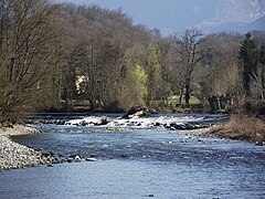
Gave de Pau near Nay, Pyrénées-Atlantiques
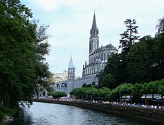
Gave de Pau at Lourdes, Hautes-Pyrénées

Gave de Gavarnie, several kilometres from the Cirque de Gavarnie

Orthez, bridge over the Gave de Pau
.JPG)

_(1).JPG)
.JPG)
Gave De Pau Media

Maintenance work on the bed of the river

Related pages
References
- ↑ 1.0 1.1 "Gave de Pau (Q---0100)" (in French). SANDRE - Portail national d'accès aux référentiels sur l'eau. Retrieved 5 March 2015.
{{cite web}}: CS1 maint: unrecognized language (link) - ↑ 2.0 2.1 "Le Gave de Pau à Bérenx (Pont de Bérenx)" (in French). Banque Hydro. Archived from the original on 5 March 2016. Retrieved 22 April 2017.
{{cite web}}: CS1 maint: unrecognized language (link) - ↑ "Source de Gave de Gavarnie ou de Pau" (in French). Géoportail. Retrieved 5 March 2015.
{{cite web}}: CS1 maint: unrecognized language (link) - ↑ "Confluence des Gaves Réunis" (in French). Géoportail. Retrieved 5 March 2015.
{{cite web}}: CS1 maint: unrecognized language (link) - ↑ "L'Ouzom (Q48-0400)" (in French). SANDRE - Portail national d'accès aux référentiels sur l'eau. Retrieved 5 March 2015.
{{cite web}}: CS1 maint: unrecognized language (link) - ↑ "La Baïse (Q53-0400)" (in French). SANDRE - Portail national d'accès aux référentiels sur l'eau. Retrieved 5 March 2015.
{{cite web}}: CS1 maint: unrecognized language (link) - ↑ "Gave d'Azun (Q46-0400)" (in French). SANDRE - Portail national d'accès aux référentiels sur l'eau. Retrieved 5 March 2015.
{{cite web}}: CS1 maint: unrecognized language (link) - ↑ "Le Laâ (Q54-0400)" (in French). SANDRE - Portail national d'accès aux référentiels sur l'eau. Retrieved 5 March 2015.
{{cite web}}: CS1 maint: unrecognized language (link) - ↑ "Ruisseau de l'Ousse (Q51-0430)" (in French). SANDRE - Portail national d'accès aux référentiels sur l'eau. Retrieved 5 March 2015.
{{cite web}}: CS1 maint: unrecognized language (link) - ↑ "L'Ousse des Bois (Q5230500)" (in French). SANDRE - Portail national d'accès aux référentiels sur l'eau. Retrieved 5 March 2015.
{{cite web}}: CS1 maint: unrecognized language (link) - ↑ "Gave d'Oloron (Q---0150)" (in French). SANDRE - Portail national d'accès aux référentiels sur l'eau. Retrieved 5 March 2015.
{{cite web}}: CS1 maint: unrecognized language (link)
Other websites
- Banque Hydro - Station Q5501010 - Le Gave de Pau à Berenx Archived 2015-02-19 at the Wayback Machine (in French)