Gräfenberg, Bavaria
Gräfenberg is a Franconian town in the district of Forchheim, in Bavaria, Germany. It is 16km southeast of Forchheim and 25km northeast of Nuremberg.
 | |
 Coat of arms | |
Location of Gräfenberg within Forchheim district  | |
| Coordinates: 49°38′N 11°15′E / 49.633°N 11.250°ECoordinates: 49°38′N 11°15′E / 49.633°N 11.250°E | |
| Country | Germany |
| State | Bavaria |
| Admin. region | Oberfranken |
| District | Forchheim |
| Municipal assoc. | Gräfenberg |
| Government | |
| • Mayor (2020–26) | Ralf Kunzmann[1] (FW) |
| Area | |
| • Total | 37.88 km2 (14.63 sq mi) |
| Elevation | 433 m (1,421 ft) |
| Population (2016-12-31)[2] | |
| • Total | 4,013 |
| • Density | 105.940/km2 (274.38/sq mi) |
| Time zone | UTC+01:00 (CET) |
| • Summer (DST) | UTC+02:00 (CEST) |
| Postal codes | 91322 |
| Vehicle registration | FO |
| Website | www |
Place
Gräfenberg is in the southern part of Little Switzerland. The town is characterised by a great range of elevation (from 400 to 550 metres). A brook, the Kalkach, flows through the town with a steep drop.
Gräfenberg is divided into 16 districts:
- The town Gräfenberg
- Lilling
- Hohenschwärz
- Kasberg
- Walkersbrunn
- Dörnhof
- Thuisbrunn
- Höfles
- Sollenberg
- Rangen
- Haidhof
- Schlichenreuth
- Guttenburg
- Neusles
- Lillinger Höhe
- Gräfenberger Hüll
Pictures

Town church and town hall
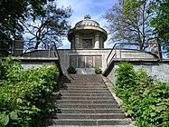
Memorial for the fallen of World War I and II above the town.

A panorama of the center and eastern part of Gräfenberg.


References
- ↑ Liste der ersten Bürgermeister/Oberbürgermeister in kreisangehörigen Gemeinden, Bayerisches Landesamt für Statistik, 15 July 2021.
- ↑ "Fortschreibung des Bevölkerungsstandes". Bayerisches Landesamt für Statistik und Datenverarbeitung (in German). January 2018.
{{cite web}}: CS1 maint: unrecognized language (link)
Other websites
 Media related to Gräfenberg at Wikimedia Commons