Interstate 296
Interstate 296 (I-296) is an Interstate Highway near Grand Rapids in Kent County, Michigan, United States. It runs between the Interstate 196 near Downtown Grand Rapids; and the Interstate 96 in Walker. It is around 3 miles (4.8 km) long and is part of the U.S. Route 131 for most of the route. It first opened in December 1962, but is now not shown on signs and is only shown as the U.S. Route 131.[4][5]
| Lua error in Module:Infobox_road/route at line 107: bad argument #1 to 'wikitext' (string or number expected, got boolean). | ||||
|---|---|---|---|---|
| Route information | ||||
| Auxiliary route of Lua error in Module:Jct at line 204: attempt to concatenate local 'link' (a boolean value). | ||||
| Length | 3.393 mi[2] (5.461 km) | |||
| Existed | December 17, 1962[1]–present | |||
| History | Approval granted to remove signage on December 3, 1979[3] | |||
| Major junctions | ||||
| South end | Lua error in Module:Jct at line 204: attempt to concatenate local 'link' (a boolean value). in Grand Rapids | |||
| North end | Lua error in Module:Jct at line 204: attempt to concatenate local 'link' (a boolean value). in Walker | |||
| Lua error in package.lua at line 80: module 'Module:Road data/size' not found. | ||||
| Highway system | ||||
| ||||
Exit list
The entire highway is in Kent County.
Lua error in package.lua at line 80: module 'Module:Road data/RJL types' not found.
Lua error in package.lua at line 80: module 'Module:Road data/RJL types' not found. Lua error in package.lua at line 80: module 'Module:Road data/RJL types' not found. Lua error in package.lua at line 80: module 'Module:Road data/RJL types' not found.
| Location | mi[2] | km | Exit[4][a] | Destinations | Notes |
|---|---|---|---|---|---|
| 0.815 | 1.312 | 87 | Leonard Street | Previously Bus. US 131 | |
| 1.566 | 2.520 | 88 | Ann Street | ||
| 3.393 | 5.461 | Lua error in Module:Jct at line 204: attempt to concatenate local 'link' (a boolean value). | Northbound exit and southbound entrance | ||
| 1.000 mi = 1.609 km; 1.000 km = 0.621 mi | |||||
Interstate 296 Media
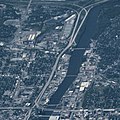
I-296, running parallel to the Grand River

Planning map for the Grand Rapids area freeways from 1955


Notes
- ↑ Most of I-296 is concurrent with US 131 and uses the exit numbers of the latter.
References
- ↑ "Driver's Boon: Int. 296 Opening Finishes City Freeway, Links Kalamazoo, Muskegon". The Grand Rapids Press: A1. December 17, 1962. .
- ↑ 2.0 2.1 Template:Cite MDOT PRFA
- ↑ Template:Cite letter
- ↑ 4.0 4.1 Template:Cite MDOT map
- ↑ Google, Inc. Google Maps – Overview Map of Unsigned I-296 [map]. Cartography by Tele Atlas.
Other websites
Lua error in Module:Attached_KML at line 224: attempt to index field 'wikibase' (a nil value).