Ivory Coast
Ivory Coast or Côte d'Ivoire,[a] officially the Republic of Côte d'Ivoire, is a country in West Africa.
Republic of Côte d'Ivoire République de Côte d'Ivoire (French) | |
|---|---|
 | |
| Motto: | |
| Anthem: | |
.svg) | |
_-_CIV_-_UNOCHA.svg) | |
| Capital | Yamoussoukro (political) Abidjan (economic) 6°51′N 5°18′W / 6.850°N 5.300°W |
| Official languages | French |
| Ethnic groups (2018) |
|
| Demonym(s) |
|
| Government | Unitary presidential republic under a parliamentary system |
| Alassane Ouattara | |
| Tiémoko Meyliet Koné | |
| Robert Beugré Mambé | |
| Legislature | Parliament of Ivory Coast |
| Senate | |
| National Assembly | |
| Independence | |
• from France | 7 August 1960 |
| Area | |
• Total | Lua error in Module:Convert at line 1850: attempt to index local 'en_value' (a nil value). (68th) |
• Water (%) | 1.4[1] |
| Population | |
• 2018 estimate | 23,740,424[2] (54th) |
• 2015 census | 24,905,843 |
• Density | Lua error in Module:Convert at line 1850: attempt to index local 'en_value' (a nil value). (139th) |
| GDP (PPP) | 2018 estimate |
• Total | $106.412 billion[3] |
• Per capita | $4,155[3] |
| GDP (nominal) | 2018 estimate |
• Total | $48.142 billion[3] |
• Per capita | $1,879[3] |
| Gini (2008) | 41.5[4] medium |
| HDI (2017) | low · 170th |
| Currency | West African CFA franc (XOF) |
| Time zone | UTC+0 (GMT) |
| Driving side | right |
| Calling code | +225 |
| ISO 3166 code | CI |
| Internet TLD | .ci |
The capital of Côte d'Ivoire is Yamoussoukro but its biggest city is Abidjan. Other cities can be found at List of cities in Côte d'Ivoire.
Geography
It borders the Gulf of Guinea to the south and five other African nations. Liberia is to the southwest, Guinea to the northwest, Mali to the north-northwest, Burkina Faso to the north-northeast, and Ghana to the east.
Districts
.png)
Ivory Coast is divided into 12 districts and 2 district-level cities. The districts were created in 2011.
| Map no. | District | District capital |
|---|---|---|
| 1 | Abidjan (District Autonome d'Abidjan) | |
| 2 | Bas-Sassandra (District du Bas-Sassandra) |
San-Pédro |
| 3 | Comoé (District du Comoé) |
Abengourou |
| 4 | Denguélé (District du Denguélé) |
Odienné |
| 5 | Gôh-Djiboua (District du Gôh-Djiboua) |
Gagnoa |
| 6 | Lacs (District des Lacs) |
Dimbokro |
| 7 | Lagunes (District des Lagunes) |
Dabou |
| 8 | Montagnes (District des Montagnes) |
Man |
| 9 | Sassandra-Marahoué (District du Sassandra-Marahoué) |
Daloa |
| 10 | Savanes (District des Savanes) |
Korhogo |
| 11 | Vallée du Bandama (District de la Vallée du Bandama) |
Bouaké |
| 12 | Woroba (District du Woroba) |
Séguéla |
| 13 | Yamoussoukro (District Autonome du Yamoussoukro) | |
| 14 | Zanzan (District du Zanzan) |
Bondoukou |
Ivory Coast Media

Prehistoric polished stone celt from Boundiali in northern Ivory Coast, photo taken at the IFAN Museum of African Arts in Dakar, Senegal

Precolonial political situation in Côte d'Ivoire with the different kingdoms, tribal societies with or without age classes.

Louis-Gustave Binger of French West Africa in 1892 treaty signing with Famienkro leaders, in present-day N'zi-Comoé Region, Ivory Coast

Arrival in Kong of new French West Africa governor Louis-Gustave Binger in 1892.

Colonies of French West Africa circa 1913
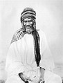
Samori Touré, founder and leader of the Wassoulou Empire which resisted French rule in West Africa
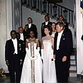
President Félix Houphouët-Boigny and First Lady Marie-Thérèse Houphouët-Boigny in the White House Entrance Hall with President John F. Kennedy and First Lady Jacqueline Kennedy in 1962.
Alassane Ouattara UNESCO 09-2011

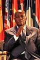
Daniel Kablan Duncan


Related pages
References
- ↑ "Côte d'Ivoire". The World Factbook. CIA Directorate of Intelligence. 24 July 2008. Archived from the original on 31 August 2020. Retrieved 8 August 2008.
- ↑ "Côte d'Ivoire". The World Factbook. CIA Directorate of Intelligence. Archived from the original on 31 August 2020. Retrieved 18 February 2017.
- ↑ 3.0 3.1 3.2 3.3 "Côte d'Ivoire". International Monetary Fund.
- ↑ "Gini Index". World Bank. Retrieved 2 March 2011.
- ↑ http://hdr.undp.org/sites/default/files/2018_human_development_statistical_update.pdf
- ↑ "Cote d'Ivoire definition". Dictionary.com. Retrieved 23 May 2014.
Notes
- ↑ The latter being pronounced /ˌkoʊt diːˈvwɑːr/ KOHT-_-DEE-vwar in English and [kot divwaʁ] (
 listen) in French.[6]