Johnston County, North Carolina
Johnston County is a county in the U.S. state of North Carolina. In 2000, 121,965 people lived there. In 2006, population was 152,143.[1] Its county seat is Smithfield.
| Johnston County, North Carolina | |
| Map | |
 Location in the state of North Carolina | |
 North Carolina's location in the U.S. | |
| Statistics | |
| Founded | June 28, 1746 |
|---|---|
| Seat | Smithfield |
| Largest town | Clayton |
| Area - Total - Land - Water |
796 sq mi (2,062 km²) 791 sq mi (2,049 km²) 4.2 sq mi (11 km²), 0.5% |
| PopulationEst. - (2017) - Density |
196,708 229.4/sq mi (89/km²) |
| Time zone | Eastern: UTC-5/-4 |
| Website: www.johnstonnc.com | |
| Named for: Gabriel Johnston | |
History
The county was made in 1746 from Craven County. It was named for Gabriel Johnston, who used to be the governor of North Carolina.
In 1752 parts of Johnston County, Bladen County, and Granville County were combined to form Orange County. In 1758 the eastern part of Johnston County became Dobbs County. In 1770 parts of Johnston County, Cumberland County, and Orange County were combined to form Wake County. And in 1855 parts of Johnston County, Edgecombe County, Nash County, and Wayne County were combined to form Wilson County.
Government
Johnston County is a member of the regional Triangle J Council of Governments.
Connected Counties
These counties are connected to Johnston County:
- Nash County, North Carolina - north-northeast
- Wilson County, North Carolina - northeast
- Wayne County, North Carolina - southeast
- Sampson County, North Carolina - south
- Harnett County, North Carolina - southwest
- Wake County, North Carolina - northwest
Major Roads
Cities and towns
These cities and towns are in Johnston County:
Newspapers in Johnston County
- Clayton News-Star
- Kenly News
- The Four Oaks-Benson News in Review
- Princeton News Leader
- The Selma News
- The Smithfield Herald[dead link]
- The Cleveland Post
- The News & Observer
- The Goldsboro News-Argus
Johnston County, North Carolina Media
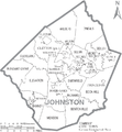
Map of Johnston County with municipal and township labels

References
- ↑ "Johnston County QuickFacts from the US Census Bureau". Archived from the original on 2011-07-13. Retrieved 2008-03-07.
Other websites
- Johnston County government official website
- Johnston County Visitors Bureau, the official site for visitor information for Johnston County