La Massana
La Massana (originally La Maçana) is one of the seven parishes of Andorra. It is in the northwest of the country. La Massana is also the name of the main town of the parish.
 | |
.svg) Flag  Coat of arms | |
| Coordinates (La Massana town): 42°32′40″N 1°30′52″E / 42.54444°N 1.51444°ECoordinates: 42°32′40″N 1°30′52″E / 42.54444°N 1.51444°E | |
| Country | Andorra |
| Parishes | La Massana |
| Villages | Anyós, Arinsal, El Pui, Erts, Escàs, L'Aldosa, Mas de Ribafeta, Pal, Puiol del Piu, Sispony, Xixerella |
| Government | |
| • Mayor | David Baró Riba |
| Area | |
| • Total | 65 km2 (25 sq mi) |
| Highest elevation | 2,942 m (9,652 ft) |
| Lowest elevation | 1,134 m (3,720 ft) |
| Population (2015)[1] | |
| • Total | 10,359 |
| • Density | 159.4/km2 (413/sq mi) |
| Time zone | UTC+1 (CET) |
| • Summer (DST) | UTC+2 (CEST) |
| ISO 3166 code | AD-04 |
| Website | Official site |
The name Massana derives from the Latin name mattianam for a variety of apple.[2]
Geography
The La Massana parish is in the northwest of the country and borders with the Ordino parish to the north, with the Ordino and Encamp parishes to the east, with the Andorra la Vella and the Escaldes-Engordany parishes to the south, with France (Ariège department) and Spain to the west.[3]
The town of La Massana has an average elevation of 1,248 m (4,094 ft) above sea level.
In the La Massana parish are the highest mountains of Andorra, including:
- Coma Pedrosa (42°35′30″N 1°26′37″E / 42.59167°N 1.44361°E), 2,943 m (9,656 ft) high, the highest mountain of the country;[4] it is in the northwest of the parish near the borders with France and Spain.
- Roca Entravessada, 2,928 m (9,606 ft) high
- Pic de Medacorba, 2,914 m (9,560 ft) high
- Pic de Sanfonts, 2,882 m (9,455 ft) high
The main river in the parish is the Valira del Nord (or Valira d'Ordino) river, one of the two branches that form the Valira river. There are several small lakes in the parish; the main lakes are Estanys Forcats, Estany de Les Truites and Estany Negre.
Population
The parish had a population, in 2015, of 10,359 inhabitants,[1] for a population density of 169.8 persons/km².
Evolution of the population in La Massana[5]

| 1981 | 1986 | 1991 | 1996 | 2001 | 2006 | 2011 | 2015 |
|---|---|---|---|---|---|---|---|
| 2,470 | 3,229 | 4,989 | 5,785 | 6,375 | 8,953 | 9,744 | 10,359 |
Villages
There are other villages and hamlets besides the main town of La Massana in the parish:
| No. | Town | Population[6] (2015) |
Altitude[7] (m) |
Notes[7] |
|---|---|---|---|---|
| 1 | Aldosa | 843 | 1,296 | Also known as L'Aldosa de la Massana. It is on the left side of the Valira d'Ordino river close to the Ordino parish. |
| 2 | Anyós | 847 | 1,307 | It is on the left side of the Valira d'Ordino (or Valira del Nord) river and on the right side of the Anyós river, just before the confluence of the rivers. |
| 3 | Arinsal | 1,620 | 1,467 | It is on the left side of the Arinsal river. |
| 4 | Erts | 473 | 1,340 | It is at the confluence of the Pal and Arinsal rivers. |
| 5 | Escàs | 162 | 1,343 | It is on the right side of the Valira d'Ordino river. |
| 6 | La Massana | 5,371 | 1,240 | The capital of the parish. It is at the confluence of the Valira d'Ordino and Arinsal rivers. |
| 7 | Pal | 260 | 1,551 | It is along Pal river. |
| 8 | Sispony | 886 | 1,315 |
Economy

The main economic activity is tourism and the parish is a major tourism destination. In winter, the main activities are skiing, snowboarding, and ski ski biking. The main ski resort, Vallnord, includes the Arinsal and Pal sectors. In summer, the main activities are hiking, climbing, mountain biking and canyoning.
Farming is also an important economic activity in the parish; here tobacco, vegetables (mainly potatoes), and cereals are grown.
Sites of interest
Gallery

Sant Climent de Pal in Pal
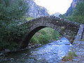
Pont de Sant Antoni de la Grella bridge

Estanys Forcats
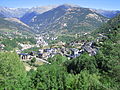
View of Anyós, La Massana


_-_panoramio.jpg)

La Massana Media
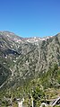
View of the Valleys of Coma Pedrosa.

Außenministerin von Andorra Maria Ubach Font. Foto: BMEIA/Lauber
- Escutd'Ordino
-
- Escutd'Ordino

- Escutd'Encamp

- Escutd'EscaldesEngordany

Emblem of Andorra la Vella
_-_73.jpg)

_(cropped).jpg)


References
- ↑ 1.0 1.1 "Population by parish". Department d'Estadísticas - Govern d'Andorra. Archived from the original on 24 September 2015. Retrieved 25 December 2016.
- ↑ "la Maçana, Situació i presentació" (in Catalan). Enciclopèdia Catalana S.A. (1999-2004). Retrieved 25 December 2016.
{{cite web}}: CS1 maint: unrecognized language (link) - ↑ "Parroquia de la Massana" (in Catalan). Enciclopèdia Catalana S.A. (1999-2004). Archived from the original on 14 December 2013. Retrieved 25 December 2016.
{{cite web}}: CS1 maint: unrecognized language (link) - ↑ "Pic de Coma Pedrosa, Andorra". Peakbagger.com. Retrieved 25 December 2016.
- ↑ "Population by parish (1981-2016)". Department d'Estadísticas - Govern d'Andorra. Retrieved 21 August 2017.[dead link]
- ↑ "Population by town". Department d'Estadísticas - Govern d'Andorra. Retrieved 25 December 2016.[dead link]
- ↑ 7.0 7.1 "Enciclopèdia Catalana" (in Catalan). Grup Enciclopèdia Catalana. Retrieved 25 December 2016.
{{cite web}}: CS1 maint: unrecognized language (link)